Navy Glider Launch 2020
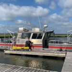
Scott Glenn and Travis Miles joined captain Jim Nickles of Monmouth University on the R/V Heidi Lynn Sculthorpe on July 22 and deployed two US Navy Slocum Gliders. These gliders…
Continue Reading
Navy Glider Launch 2020
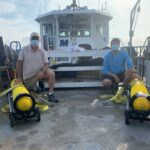
Scott Glenn and Travis Miles joined captain Jim Nickles of Monmouth University on the R/V Heidi Lynn Sculthorpe on July 22 and deployed two US Navy Slocum Gliders. These gliders…
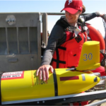
July 21st, 2020 The Mid-Atlantic 2020 Glider Season began last week with the launch of RU_33 off the coast of Tuckerton, NJ. This is the first of many Mid-Atlantic glider…
Title: Collaborative Research: Developing a profiling glider pH sensor for high resolution coastal ocean acidification monitoring Funding Agency: NSF Project Lead: Grace Saba, Travis Miles Partners: Teledyne Webb, Waterlab Period…

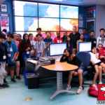
Students from Brooklyn's School for Human Rights visited the COOLroom and glider lab today. Discussions ranged from our current work at Palmer Station in Antarctica studying penguin populations, to more…
The technology used to observe ocean acidification – the shift in ocean chemistry driven by an increase in the amount of carbon dioxide in the atmosphere due to the burning…
Grace Saba, assistant professor in the Department of Marine and Coastal Sciences (DMCS), is the lead principal investigator and John Wilkin, professor in DMCS, is co-principal investigator of $1,499,895 million…
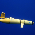
Underwater robot gliders are measuring air and sea interaction during hurricanes in the mid-Atlantic region. The little yellow submarines are part of a collaborative effort between Rutgers and Monmouth universities.…
RUCOOL was visited by forty students from the Rutgers Future Scholar’s program. They learned about topics ranging from what happens at the NJ beaches in the summer, to the ongoing…