The Sentinel Mission
Sentinel Home The Sentinel Mission Flight Viewer Our Goals Our Challenges UN Ocean Decade What is a Glider? What Gliders Can Do Slocum Gliders The Sentinel Glider History Doug Webb…
Continue Reading
The Sentinel Mission
Sentinel Home The Sentinel Mission Flight Viewer Our Goals Our Challenges UN Ocean Decade What is a Glider? What Gliders Can Do Slocum Gliders The Sentinel Glider History Doug Webb…
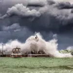
Lessons learned from ocean observations during hurricanes Irene and Sandy pushed the U.S. to deploy a fleet of underwater robots during every hurricane season. As extreme weather events are becoming…
Oceanographic HF Radar Data Preservation in Wind Turbine Interference Mitigation Coastal oceanographic high frequency radars (HFR) are used to measure the current of the ocean at the surface. HF signals…
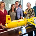
New Jersey is the first state in the country to make climate change a part of the public school curriculum. Rutgers University hosted a workshop Thursday to help educators integrate…
Sentinel Home The Sentinel Mission Flight Viewer Our Goals Our Challenges UN Ocean Decade What is a Glider? What Gliders Can Do Slocum Gliders The Sentinel Glider History Doug Webb…
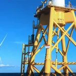
Q&A on Recent Whale Strandings and Offshore Wind Energy Development Are whale strandings increasing along the Jersey Shore? Recent whale strandings along New Jersey and New York continue a…
Mission Statement The Sentinel Mission is a daring scientific endeavor aiming to make history by completing the first circumnavigation journey by an autonomous underwater vehicle (AUV). Through the use of…
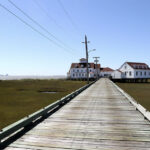
The wooden causeway to the Rutgers University Marine Field Station in Little Egg Harbor Township, where Superstorm Sandy made landfall in New Jersey. To the left, the casino hotels of…