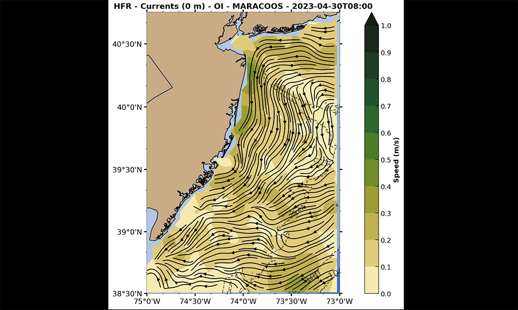
National Weather Service Wave Forecasting Rutgers and MARACOOS are working with NOAA Weather Forecasting Office (WFO) Philadelphia to develop wave measurements from High Frequency (HF) radar.  The HF radars traditionally provide surface current measurements that are utilized by NOAA and US Coast Guard.  Another measurement that is under development is wave height, period and direction.  Recently WFO Philadelphia utilized HF radar data to analyze the swell from Hurricane Larry and forecaster Nicholas Carr mentioned it in his rip current forecast discussion.  They also compared HF radar measurements with buoy observations in May 2021 (see below) and the HF radar retrievals compared favorably with the buoy observations.

Rutgers had to retire the High Frequency radar installation at Cape May Point, New Jersey this September.  The radar installation was hosted at the Saint Mary by-the-Sea Retreat House and is closing permanently on September 24, 2021.  Saint Mary by-the-Sea was a retreat house sponsored by the Congregation of the Sisters of Saint Joseph of Philadelphia to provide opportunities for annual retreat for members of their Congregation. We would like to thank Sister Kathy Hart for serving as our point of contact for the duration of the deployment.  The radar was installed in 2007, thus bringing an end to this 14-year time series.  We will be pursuing nearby locations to relocate the radar equipment in the coming months.

Dr. Hugh Roarty from Rutgers University along with colleagues Dr. Anthony Kirincich and Ms. Eve Cinquino from Woods Hole Oceanographic Institution (Figure 1) installed a 13 MHz CODAR SeaSonde to collect radar data in the vicinity of the Orsted Block Island Wind Farm .  The radar was installed with help from the Galilee Beach Club providing the real estate and power for the equipment.  Special thanks to Tracy Baran and David Field from the Beach Club who assisted with the permissions and installation.  The system will run for one month collecting radar and surface current data in the presence of 5 wind turbines (Figure 2).  This will allow CODAR Ocean Sensors to test their mitigation algorithms to minimize the interference from offshore wind turbines on coastal radars.  This work was funded by a grant from the NOAA IOOS Ocean Technology Transition program.

Rutgers scientists observed the ocean and atmospheric response to a derecho that passed through NJ and caused severe damage in several towns.  A Rutgers meteorological tower in Tuckerton NJ recorded a peak wind gust of 54 mph alongside a 21-degree temperature drop in only 15 minutes.  The HF-Radar station at Bradley Beach, NJ, part of the larger Mid-Atlantic Regional Association Coastal Ocean Observing System network, detected a surface disturbance at 1:20 pm local and the station in Brant Beach registered a similar response thirty minutes later at 1:50 pm local.  This time delay was the result of the southeast track of the storm first reaching the northern station at Bradley Beach and then reaching the southern station in Brant Beach.  This event is similar to another a meteotsunami that Rutgers detected in 2013 which sent several people to the hospital.  NOAA estimates that 25 meteotsunamis impact the east coast of the United States each year. Tsunami detection q-factor from the Bradley Beach HFR station.  The station recorded a tsunami signal at 17:27 GMT. Tsunami detection q-factor from the Brant Beach HFR station.  The station recorded a tsunami signal at 17:50 GMT. Plot of air temperature at the Rutgers meteorological tower located in Tuckerton, NJ.  The station recorded a 14-degree C (21 degrees F) drop in temperature in only 15 minutes. Plot of wind speed and gusts at the Rutgers meteorological tower located in Tuckerton, NJ.  The station recorded a peak gust of 54 mph at 17:18 GMT. Plot of atmospheric pressure at the Rutgers meteorological tower located in Tuckerton, NJ.  The station recorded a 3 mb pressure spike which is associated with the formation of meteotsunamis. Main photo credit nj.com

Dr. Hugh Roarty visited with Dr. Erick Fredj from Jerusalem College of Technology in Jerusalem Israel from January 27-31, 2020.  Dr. Fredj has been a longtime collaborator with Rutgers University.  Dr. Roarty and Dr. Fredj discussed the state of the art for measuring and quantifying oceanic surface transport in the Mid Atlantic Bight.  They plan on conducting an experiment this coming summer looking to measure ocean dispersion with drifters and High Frequency radar.

Two drifters from Pacific Gyre were deployed on Friday November 15, 2019. The drifters were deployed as part of a validation experiment for the surface current products that Rutgers produces. The drifters made several loops inside Raritan Bay then made landfall due to the northeast winds that struck the area over the weekend. The data from the drifter will be used to calibrate the MARACOOS High Frequency Radar Network.

A drifter was released this past Tuesday as part of the Ocean Methods and Data Analysis course just west of Sandy Hook. The drifter was constructed by St. Hubert Catholic High School in Philadelphia, PA this past spring. You can track the progress of the drifter here. NOAA Drifter The drifter was provided to the school as part of the NOAA Northeast Fisheries Science Center Drifter program. https://www.nefsc.noaa.gov/drifter/ The data from the drifter will be used to calibrate the MARACOOS High Frequency Radar Network. https://maracoos.org/hfradar.shtml Acknowledgments Thanks to Prof. Grace Saba and Nicole Waite for deploying the drifter. Thanks to Mr. Jeff Franks who led the construction and contacted Rutgers to be part of the deployment.