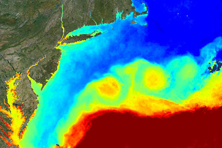
Are you planning on heading out on the water for Memorial Day Weekend?  Before you head out, check the RUCOOL Satellite Page for the latest satellite data to supplement the summer kick-off fun! For more information on our satellites and how to interpret the information, check out our How to Read a Sea-Surface Temperature Map

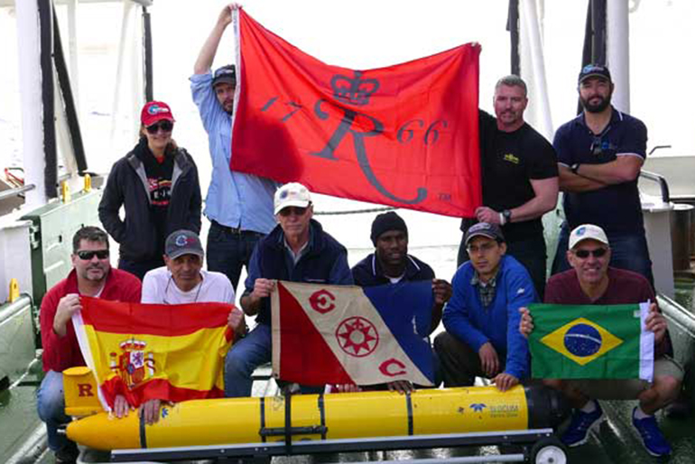
After 282 days at sea, on March 31, 2016 the Rutgers Slocum Electric Underwater Glider, RU29, “Challenger” was recovered off the coast of South Africa completing the first crossing of the South Atlantic by an autonomous underwater vehicle. The glider was launched from Ubatuba, Brazil on June 23, 2015. This also completes the first circumnavigation of an ocean basin by an autonomous underwater vehicle. “Challenger” was first deployed January 11, 2013 from Cape Town, South Africa, was recovered, rebatteried and redeployed off of Ascension Island in November of that year, and then recovered off of Brazil on May 18th 2014 before the most recent trek back to South Africa. This excursion is part of The Challenger Glider Mission: an initiative to circumnavigate the globe with the autonomous underwater vehicles to collect an unprecedented data set from the ocean that is fed in real time to the US global ocean models to better enhance their forecasts. The mission also strives to spread ocean literacy around the globe and has resulted in a number of educational talks being given around the world. Part of this educational aspect is the heavy involvement by undergraduates at Rutgers University where during the semester, groups of students in the Ocean Observatories course monitor aspects of the mission such as the engineering and science data from the glider, ocean dynamics, biology of the regions and culture of the collaborating countries and potential stopping points. A select number of students then have the opportunity to continue working on projects through summer internships funded by Teledyne Webb Research that have lead to a number of student publications in the Marine Technology Societies Proceedings including: “Model comparison for transatlantic ocean glider flight: Student analysis of modern circumnavigation” (A. Morrison et al., OCEANS’15 MTS/IEEE Washington http://ieeexplore.ieee.org/stamp/stamp.jsp?tp=&arnumber=7404505&isnumber=7401802) “Glider advancements in efficiency: Enhancing factors necessary for ocean-wide flights” (L. Ramsay et al., OCEANS’15 MTS/IEEE Washington http://ieeexplore.ieee.org/stamp/stamp.jsp?tp=&arnumber=7404553&isnumber=7401802) “Ocean predictive skill assessments in the South Atlantic: Crowd-sourcing of student-based discovery” (R. Sacatelli et al., Oceans – St. John’s, 2014, http://ieeexplore.ieee.org/stamp/stamp.jsp?tp=&arnumber=7003134&isnumber=7002974) “The Challenger Glider Mission: A global ocean predictive skill experiment” (C. Dobson et al., Oceans – San Diego, 2013 http://ieeexplore.ieee.org/stamp/stamp.jsp?tp=&arnumber=6741236&isnumber=6740936). The success of RU29 follows the previous Challenger Mission Deployments flown by Teledyne’s glider “Silbo” which went from Iceland to the Azores, Azores to Canary Islands, and Canary Islands to Barbados from June 2011 to August 2013. Later this year, Silbo will be redeployed from Massachusetts to cross the North Atlantic to Northern Europe, while RU29 will be deployed from the Western Coast of Australia and circumnavigate the Indian Ocean. For more information on the Challenger Glider Mission check out the website here: http://challenger.marine.rutgers.edu/ and the blog: http://challenger.marine.rutgers.edu/blog/?page_id=15157

The National Science Foundation (NSF) and the Ocean Observing Steering Committee hosted a meeting at NSF in early January for the coastal oceanography community to harken the opening of the OOI program. RU COOL along the Rutgers Discovery Informatics Institute has been building the cyberinfrastructure component of the OOI in partnership with Raytheon and Applied Science Associates. The meeting in January 2016 announced the opening of the OOI Data Portal is that now OPEN to view data. Click here to create your login. The OOI Data Portal immediately to the community for viewing data while we continue to conduct configuration validation of data streams. Data viewed through the time series plotting function are preliminary and subject to change as the team continues their quality control processes and the validation of OOINet. Your feedback is welcome and appreciated. Beyond that we are providing access to validated OOI data while this process is being completed through the OOI Website. Data currently available for download from the OOI Website includes: All historical Cruise Data Validated OOI dataset files through a THREDDS server. The number of available datasets will increase over time as data are validated. The list of datasets on the THREDDS server are based on the Essential Ocean Variables identified by the OOI Science Oversight Committee (SOC) and the scientific community. An additional feature available on the OOI Data Portal at this time is HD video streams at a hydrothermal vent site on the Axial Seamount. Live video streams of the actively venting chimney are provided periodically throughout the day during the hours of 1:00, 4:00, 7:00, and 10:00 ET & PT, for a duration of 14 minutes. Beyond the website, there are additional ways to get information about using the OOI. OOI Operations Staff are available to meet with potential investigators who wish to submit proposals to deploy instruments on the OOI. Investigators can schedule an appointment to meet virtually with OOI Operations Staff to discuss technical requirements, testing, and answer any other questions researchers might have regarding adding instrumentation to the OOI arrays. Click here to view available times.