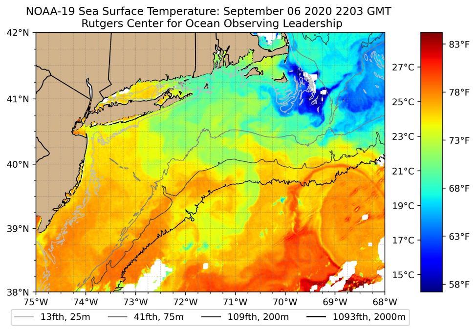
RUCOOL has been delivering real-time imagery to its website since 1994. This month we are introducing a new faster and easier to use viewer for all new and archived imagery, which is located here. Not only has the front end GUI been updated, but so have the images themselves. The new images have higher resolution detail throughout all of the 23 sea surface temperature geographic areas. Through the fall of 2020, we will continue to generate both the new and old imagery, as well as maintain the both the new GUI and the existing pages here. Once the northeast US fishing and beach season concludes later this year, we will take down the old site and stop producing the older imagery format. Additionally, we wanted to make you aware of the Mid-Atlantic Regional Association Coastal ocean Observation System’s (MARACOOS) OceansMap viewer. This state-of-the-art interactive system not only has the capability to display satellite data, but also data from over 100 different sources, including hurricane tracks, winds, currents, forecasts, station and buoy locations. Users can interact with the map clicking to see the latest temps, wind speeds, wave heights, etc. RUCOOL is proud to be part of the MARACOOS team. We thank the thousands of you that have used our data over the last quarter of a century, and look forward to providing you satellite imagery and ocean data for years to come.

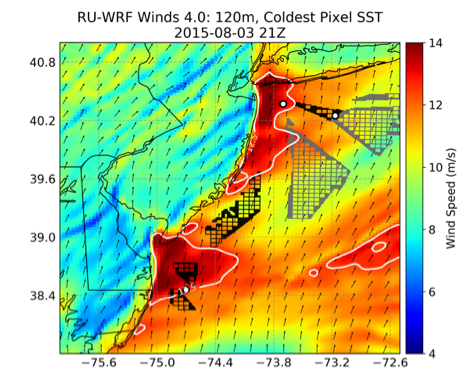
The National Renewable Energy Laboratory (NREL) recently completed an independent validation study of the performance of the RUCOOL real-time weather model (RU-WRF) that is used for wind resource assessment work. Their study evaluated the input data and parameters used by the RU-WRF model, including RUCOOL’s innovative Coldest Dark Pixel sea surface temperature product, and compared it to other model forcing data and model setups, including a setup that mirrors the NREL WIND Toolkit. In particular, they found that the planetary boundary layer scheme used in RU-WRF was more accurate for offshore wind resource modeling, particularly when upgrading the underlying version of the Weather Research and Forecasting (WRF) model to version 4.0. Additionally, they found that the coldest pixel SST product was more accurate than other widely used SST products for this region, which helped to provide improvements in model accuracy. More information on the model, including model output, is available on the RU-WRF Model page. The full report can be found through NREL. Support for RU-WRF and the validation study has been provided by the State of New Jersey Board of Public Utilities.

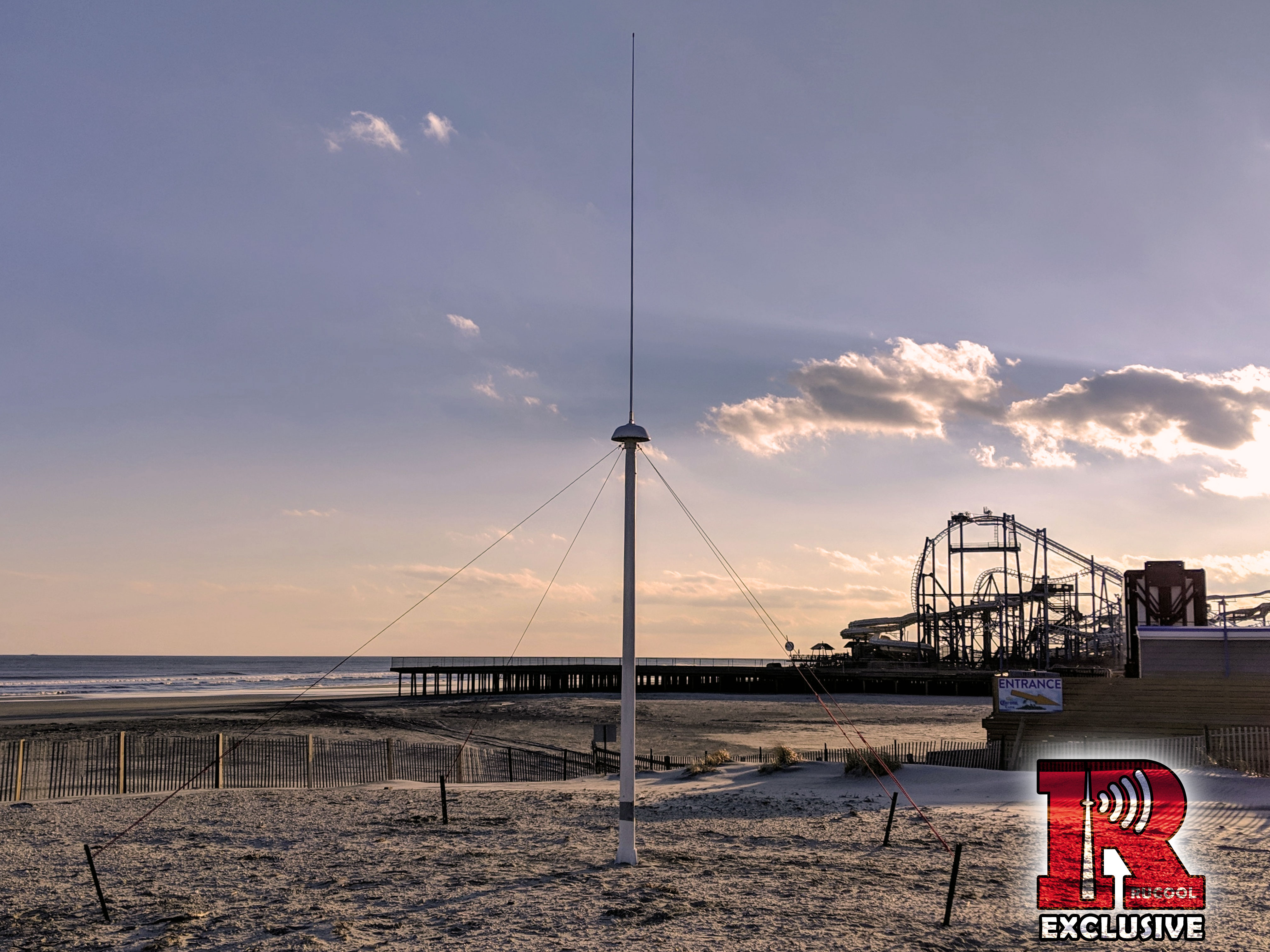
The 13 MHz CODAR SeaSonde is operating once again in North Wildwood. The station which was first installed in 2012 had to be turned off due to construction on a new boardwalk. Working with officials from the City of North Wildwood we were able to relocate the station and started measuring surface currents on January 25, 2019. We wish to thank the City of North Wildwood for their support of this important research endeavor.

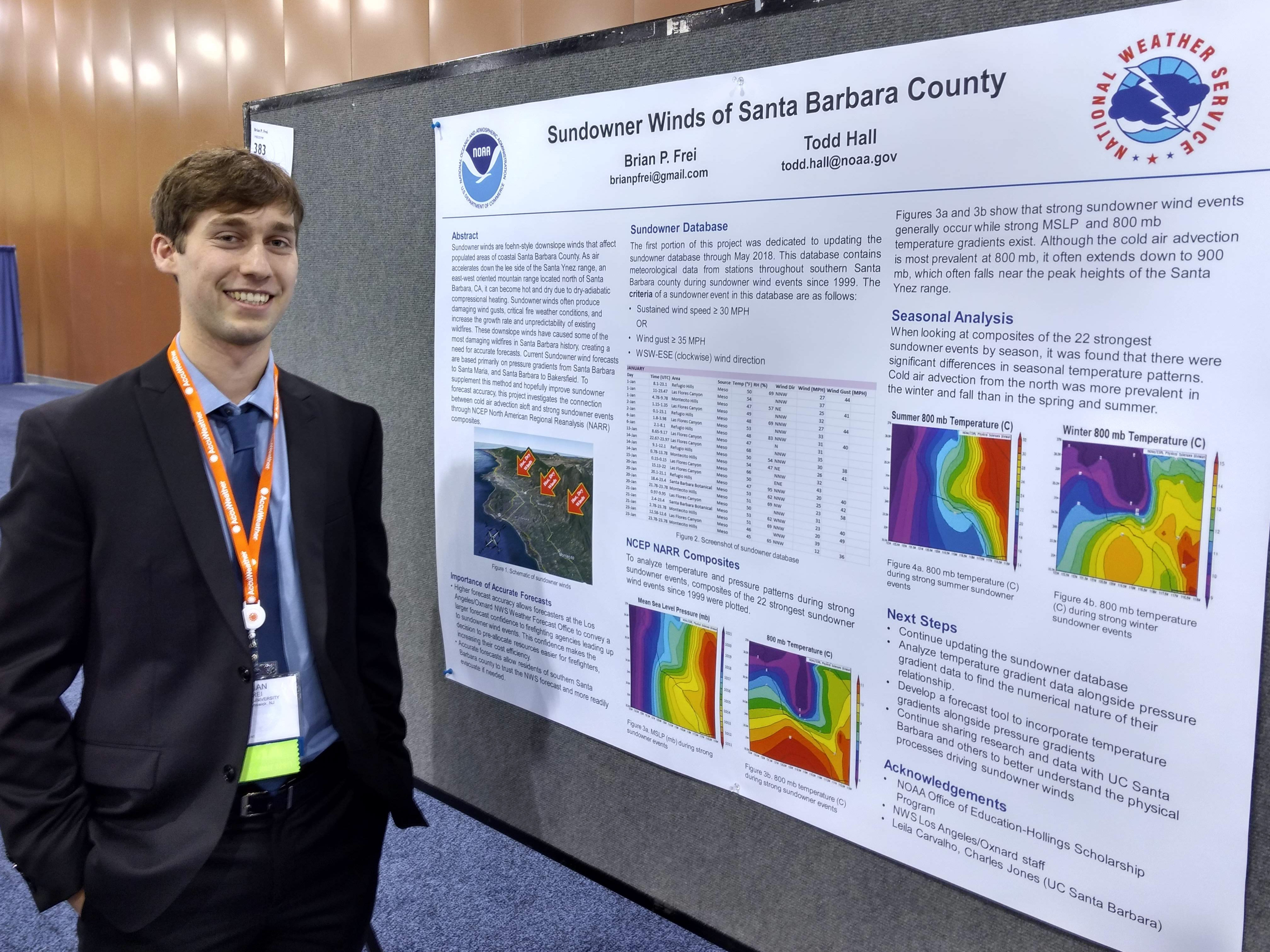
Several RUCOOL affiliates attended and presented at the 99th Annual Meeting of the American Meteorological Society (AMS) in Phoenix, AZ from January 7 through 10, 2019. This meeting gathers more than 4000 scientists and policymakers to discuss the latest in weather and ocean-related operations and research, with this year’s annual theme focused on Understanding and Building Resilience to Extreme Events by Being Interdisciplinary, International, and Inclusive. This year, Dr. Joseph Brodie presented on Utilizing Climatological Analysis to Improve Forecasting of Offshore Wind Ramps, while undergraduate intern Brian Frei presented a poster on his Hollings summer project with the NOAA National Weather Service Forecast Office in Oxnard, CA on Sundowner Winds of Santa Barbara County. Additionally, Dr. Brodie and Dr. Travis Miles were co-authors on the presentation Validation and Comparison of Mesoscale Model Setups for Offshore Wind Resource Assessment: A New Jersey Case Study, by lead author Andrew Kumler of the National Renewable Energy Laboratory. PDFs of these presentations are available from our Presentations page!

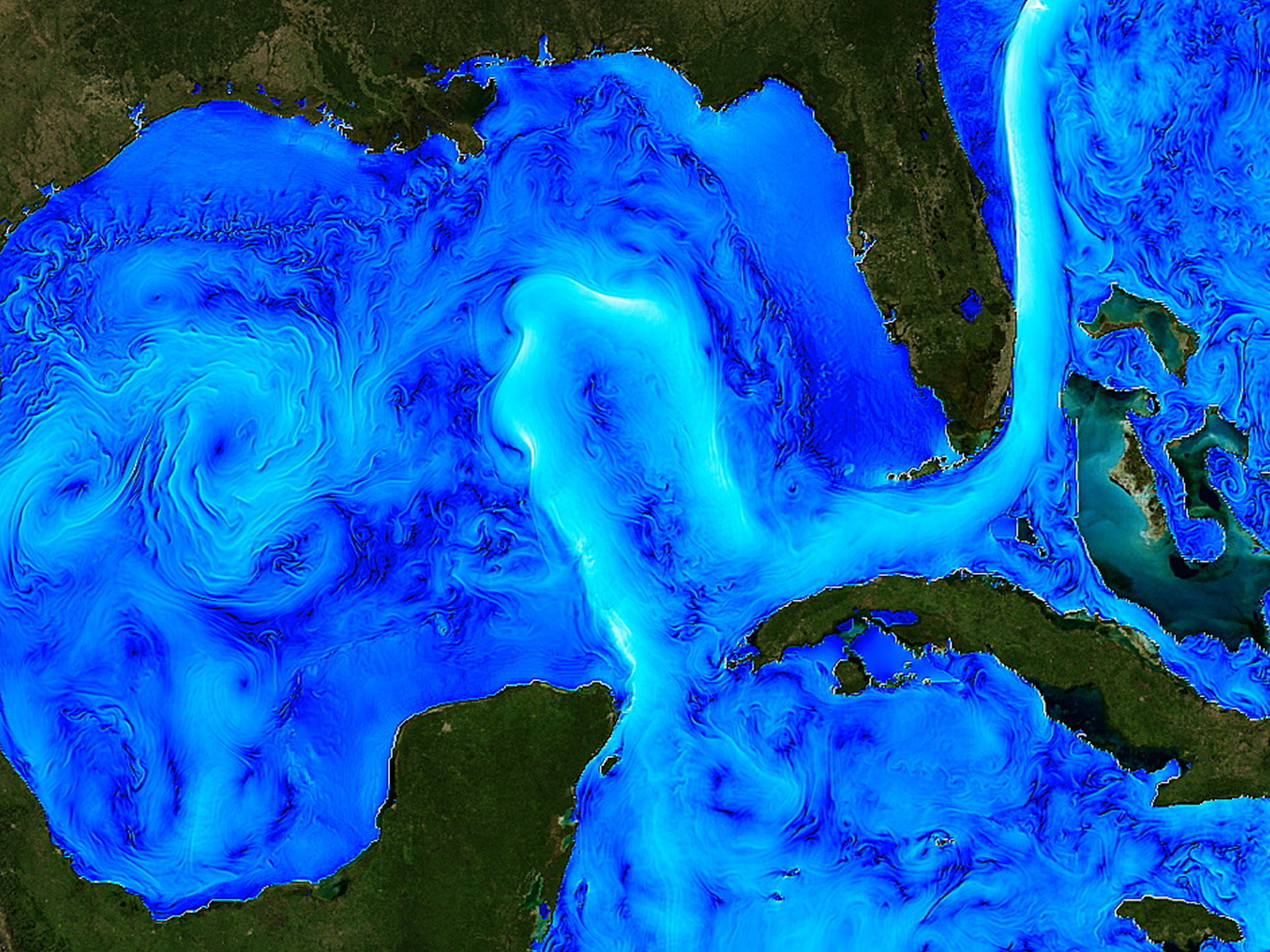
FOR IMMEDIATE RELEASE | Research Campaign to Advance Understanding of Gulf of Mexico Loop Current Moves Forward By Awarding $10.3 Million in Initial Grants WASHINGTON – Following recommendations from a National Academies of Sciences, Engineering, and Medicine report released earlier this year, the National Academies’ Gulf Research Program (GRP) is developing a long-term research campaign to improve understanding and prediction of the Gulf of Mexico Loop Current System (LCS). In support of this effort, the GRP today announced $10.3 million in grant awards for eight new projects to conduct studies and collect data and observations that will inform the planning and launching of the long-term research campaign. The LCS is the dominant ocean circulation feature in the Gulf of Mexico. It influences all types of ocean processes and has implications for a wide range of human and natural systems, including oil and gas operations, storm and hurricane intensity, coastal ecosystems, and industries such as fishing and tourism. However, despite its far-reaching impacts, knowledge about the underlying dynamics that control the behavior of the LCS is limited. “The campaign being planned is a major undertaking. Scientists have been trying to get a handle on the Loop Current for decades, and they’ve made great progress, but there’s never been a long-term, comprehensive, internationally and multi-institutionally coordinated effort,” said Kelly Oskvig, program officer for the GRP. The National Academies report Understanding and Predicting the Gulf of Mexico Loop Current: Gaps and Recommendations identified existing knowledge gaps about the LCS and called for a long-term research campaign to help improve understanding and prediction of the LCS. The report outlined a series of recommendations for near-term and long-term activities needed for a campaign that is expected to take around 10-12 years and require collaborations among many different groups and funders. The GRP recently formed a standing committee of external experts to advise on planning and implementing a LCS research campaign. For more information, visit nationalacademies.org/ugos. “Over time this campaign could generate valuable knowledge able to help improve understanding of the Gulf’s complex oceanographic systems, promote safer offshore operations, facilitate disaster response, and protect coastal communities and ecological resources, among other things,” said Oskvig. Eight new projects were selected for grant awards through the first funding competition related to the LCS research campaign. The solicitation sought projects that would conduct specific studies or collect particular data and observations identified in the report as short-term needs to assist with the long-term research campaign. Planning for the next funding competition, which will also be directed at advancing the long-term LCS research campaign, is now underway and expected to open in 2019. The eight projects chosen to receive awards totaling $10.3 million through the first funding competition for the LCS research campaign were selected through the GRP’s standard external peer review process. Listed in alphabetical order by project title, the projects are: Dry Tortugas and Lower Keys High Frequency Radars Award Amount: $1,371,027 Project Director: Clifford Merz (University of South Florida) Project Team Affiliation: University of South Florida in cooperation with Rutgers University and University of Miami Overview: This project will procure, install, and operate high frequency radar systems to measure surface currents at three locations in the Straits of Florida region of the Gulf of Mexico: Fort Jefferson/Dry Tortugas National Park, Key West, and Marathon. Data from the systems will provide new, real-time data for model assimilation and validation to better understand the evolution of the LCS. Gulf of Mexico Loop Current and Eddy Observations from HF Radar Systems Award Amount: $1,229,424 Project Director: Stephan Howden (University of Southern Mississippi) Project Team Affiliation: University of Southern Mississippi in cooperation with CODAR Ocean Sensors, Shell, and Rutgers University Overview: This project will procure, install, and operate high frequency radar systems to measure surface currents from two offshore platforms at locations in the northeastern most areas of oil and gas operations in the Gulf of Mexico. Data from the systems will provide new, real-time data for model assimilation and validation to better understand the evolution of the LCS. Informing the Loop Current Campaign: Data Compilation to Improve Understanding, Simulation and Prediction of the Loop Current System Award Amount: $647,813 Project Director: Barbara Kirkpatrick (Gulf of Mexico Coastal Ocean Observing System Regional Association) Project Team Affiliation: Gulf of Mexico Coastal Ocean Observing System Regional Association in cooperation with Fugro, Harte Research Institute, Ocean Sierra, RPS, Texas A&M University—College Station, Texas A&M University—Corpus Christi, and Woods Hole Group Overview: This project will design, develop, deploy, and maintain an information system to digitally compile, update, analyze, and make publicly accessible physical oceanographic and hydrographic data from Gulf of Mexico Loop Current field studies. The system will be an important component of future data compilation efforts for a long-term LCS research campaign. Loop Current Floats: Near Real-Time Hydrography and Deep Velocity in the Loop Current System Using Autonomous Profilers Award Amount: $1,155,371 Project Director: Amy Bower (Woods Hole Oceanographic Institution) Project Team Affiliation: Woods Hole Oceanographic Institution in cooperation with Centro de Investigación Científica y de Educación Superior de Ensenada (Center for Scientific Research and Higher Education at Ensenada) Overview: This project will procure, deploy, and maintain a fleet of autonomous ocean dynamics-instrumented profiling floats to measure temperature, salinity, and current velocities in LCS active areas of the eastern Gulf of Mexico. Numerical Modeling Award Amount: $2,100,946 Project Director: Ruoying He (North Carolina State University) Project Team Affiliation: North Carolina State University in cooperation with Centro de Investigación Científica y de Educación Superior de Ensenada (Center for Scientific Research and Higher Education at Ensenada), Chevron, Florida State University, Massachusetts Institute of Technology, Scripps Institution of Oceanography, and University of California – Santa Cruz Overview: This project will perform assessments of existing Gulf of Mexico forecasting systems to test the performance and sensitivity of current models in resolving both surface and subsurface circulation and to evaluate long-range prediction capabilities. Passive Gulf of Mexico Loop Current Observations from HF Radar Across the Yucatan Strait Award Amount: $844,263 Project Director: Anthony Knap (Texas A&M University—College Station)

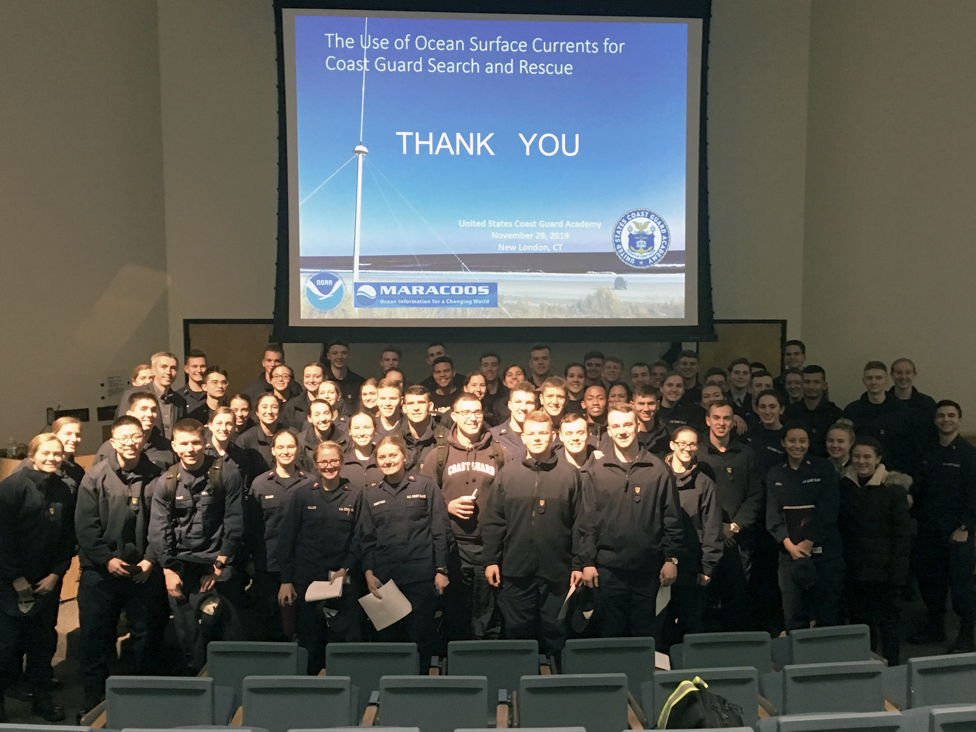
Dr. Hugh Roarty delivered a talk to the cadets of the United States Coast Guard Academy on Thursday November 29, 2018, on behalf of MARACOOS. His talk was entitled “The Use of Ocean Surface Currents for Coast Guard Search and Rescue” and was part of the Coast Guard Academy Science Lecture Series.

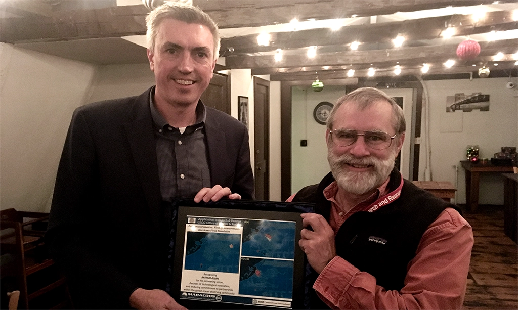
On behalf of MARACOOS, Dr. Hugh Roarty presents a plaque to Mr. Art Allen on the occasion of his retirement from the United States Coast Guard. Mr. Allen was recognized for his pioneering vision, decades of technological innovation and enduring commitment to partnerships within the global ocean observing community. His work with the Coast Guard Office of Search and Rescue (SAR) focused on determining the drift trajectory of common search objects and application of survival and hypothermic models in SAR planning. He served as liaison between the USCG and the oceanographic community to articulate USCG mission needs and determine which environmental data products were best for USCG search and rescue missions.