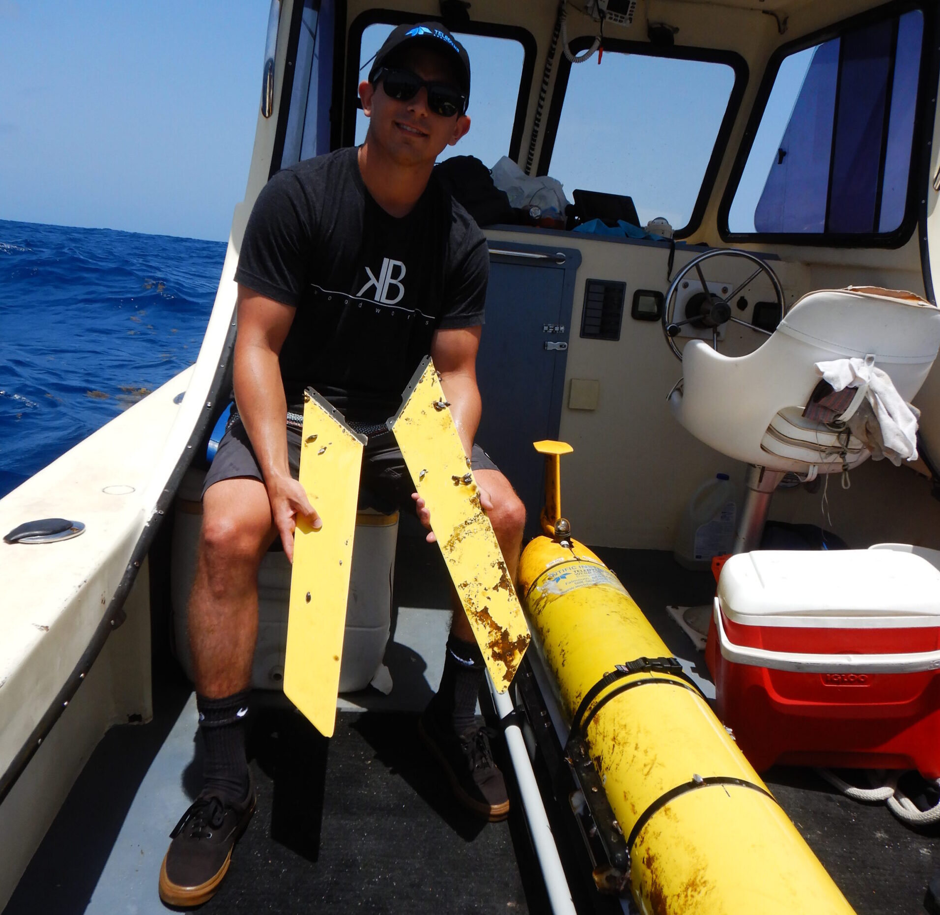
Skip to content
Rutgers | Rutgers-SEBS | Rutgers-DMCS | Search Rutgers
RUCOOL | Rutgers Center for Ocean Observing Leadership
  • About Us
    • Our Team
    • Graduate Student Alumni
    • Facilities
    • Outreach
      • Featured Outreach
      • Resources and Tools for Scientists & Educators
    • Awards and Recognitions
    • Unselfish Ocean Champions
    • Movies, Videos, Photos, Logos & Templates
  • Education
    • Why Study At Rutgers?
    • undergraduate program
      • Undergraduate Brochure
    • graduate program
    • Master of Operational Oceanography
    • Glider Technology Camp
    • HF Radar Technology Camp
    • Student Awards
    • The Sentinel Mission
  • Research
    • Hurricane Science
    • Offshore Wind
    • Polar Science / LTER
      • Palmer LTER
    • Ocean Acidification
    • Integrated Ocean Technology
    • Empowering the Next Generation
    • Current Research Projects
    • Publications
    • Presentations
  • Data
    • Technology
      • Ocean Robotics
      • Ocean Radar
      • Remote Sensing
      • Meteorology and Modeling
    • Satellites
      • Remote Sensing Overview
      • Satellite Data
      • About Satellites
      • How to read a Sea Surface Temperature Map
    • Codar
      • How Does HF Radar Work?
      • Surface Current Viewer
      • Codar Data: ERDAPP
      • Codar Data: Thredds
      • Glider Piloting Tool
    • Underwater Gliders
      • Ocean Robotics Overview
      • Glider Data
      • Glider Deployments
      • About Underwater Gliders
      • Glider Operation Checklists
    • Meteorological Monitoring and Modeling
      • Meteorology and Modeling Overview
      • Coastal Metocean Monitoring Station
      • RUWRF Mesoscale Meteorological Model
      • Evaluation of Operational Ocean Models
    • Signature Data Sets
  • News
    • Reports
    • Jobs
  • Giving
  • Contact
  • Blogs
    • Challenger
    • Hurricanes
    • Operations
    • Polar Oceans
  • Toggle website search
Menu Close
  • About Us
    • Our Team
    • Graduate Student Alumni
    • Facilities
    • Outreach
      • Featured Outreach
      • Resources and Tools for Scientists & Educators
    • Awards and Recognitions
    • Unselfish Ocean Champions
    • Movies, Videos, Photos, Logos & Templates
  • Education
    • Why Study At Rutgers?
    • undergraduate program
      • Undergraduate Brochure
    • graduate program
    • Master of Operational Oceanography
    • Glider Technology Camp
    • HF Radar Technology Camp
    • Student Awards
    • The Sentinel Mission
  • Research
    • Hurricane Science
    • Offshore Wind
    • Polar Science / LTER
      • Palmer LTER
    • Ocean Acidification
    • Integrated Ocean Technology
    • Empowering the Next Generation
    • Current Research Projects
    • Publications
    • Presentations
  • Data
    • Technology
      • Ocean Robotics
      • Ocean Radar
      • Remote Sensing
      • Meteorology and Modeling
    • Satellites
      • Remote Sensing Overview
      • Satellite Data
      • About Satellites
      • How to read a Sea Surface Temperature Map
    • Codar
      • How Does HF Radar Work?
      • Surface Current Viewer
      • Codar Data: ERDAPP
      • Codar Data: Thredds
      • Glider Piloting Tool
    • Underwater Gliders
      • Ocean Robotics Overview
      • Glider Data
      • Glider Deployments
      • About Underwater Gliders
      • Glider Operation Checklists
    • Meteorological Monitoring and Modeling
      • Meteorology and Modeling Overview
      • Coastal Metocean Monitoring Station
      • RUWRF Mesoscale Meteorological Model
      • Evaluation of Operational Ocean Models
    • Signature Data Sets
  • News
    • Reports
    • Jobs
  • Giving
  • Contact
  • Blogs
    • Challenger
    • Hurricanes
    • Operations
    • Polar Oceans
  • Toggle website search

In The News

Read more about the article RUCOOL’s New Satellite Imagery Viewer

RUCOOL’s New Satellite Imagery Viewer

RUCOOL has been delivering real-time imagery to its website since 1994. This month we are introducing a new faster and easier to use viewer for all new and archived imagery,…

Continue ReadingRUCOOL’s New Satellite Imagery Viewer
Read more about the article RUCOOL Teams Up with Our Partners in the Caribbean

RUCOOL Teams Up with Our Partners in the Caribbean

The Ocean and Coastal Observing –Virgin Islands (OCOVI) team that is part of the Caribbean Coastal Ocean Observing System (CARICOOS), partnered up with RUCOOL to deploy the RU29 glider hurricane…

Continue ReadingRUCOOL Teams Up with Our Partners in the Caribbean
Read more about the article SEBS Virtual Science Cafe Series: Hot Days in a Melting West Antarctic Peninsula

SEBS Virtual Science Cafe Series: Hot Days in a Melting West Antarctic Peninsula

Travel down to the West Antarctic Peninsula, one of the fastest warming locations on Earth. The rising temperatures are decreasing the amount of sea ice present and changes are now…

Continue ReadingSEBS Virtual Science Cafe Series: Hot Days in a Melting West Antarctic Peninsula
Read more about the article Congratulations to Joe Anarumo for Successfully Defending his Masters Defense

Congratulations to Joe Anarumo for Successfully Defending his Masters Defense

Congratulations to Joe Anarumo who successfully presented his Masters work on Wednesday. Joe is a member of the first cohort of the Operational Oceanography masters program. During his time in…

Continue ReadingCongratulations to Joe Anarumo for Successfully Defending his Masters Defense
Read more about the article Congratulations to Julia Engdahl for her successful Masters defense

Congratulations to Julia Engdahl for her successful Masters defense

Congratulations to Julia Engdahl who successfully defended her Masters thesis! Part of the first cohort of DMCS’ new program in Operational Oceanography, Julia has developed deep expertise in observing systems…

Continue ReadingCongratulations to Julia Engdahl for her successful Masters defense
Read more about the article Robots Are Tracking Hurricanes and Improving Forecast Accuracy

Robots Are Tracking Hurricanes and Improving Forecast Accuracy

Torpedo shaped machines known as Slocum ocean gliders travel anywhere from the ocean's surface to more than 3,000 feet underwater, collecting critical data that not only improves forecasts but will…

Continue ReadingRobots Are Tracking Hurricanes and Improving Forecast Accuracy
Read more about the article Eight Weeks of Intensive Virtual Learning

Eight Weeks of Intensive Virtual Learning

Two weeks. That is the amount of time Janice McDonnell and Sage Lichtenwalner, Co-PIs of the OOI Ocean Data Lab Project, had to create an eight-week intensive, hands-on virtual program…

Continue ReadingEight Weeks of Intensive Virtual Learning
  • Go to the previous page
  • 1
  • …
  • 31
  • 32
  • 33
  • 34
  • 35
  • 36
  • 37
  • …
  • 44
  • Go to the next page

Find Us

Center for Ocean Observing Leadership
Department of Marine and Coastal Sciences
School of Environmental and Biological Sciences
Rutgers, The State University of New Jersey

71 Dudley Rd
New Brunswick, NJ 08901-8520

848-932-6555

webocean@marine.rutgers.edu

Links

  • Rutgers, The State University of New Jersey
  • Rutgers–New Brunswick
  • myRutgers | Search Rutgers
  • Department of Marine and Coastal Sciences
  • School of Environmental and Biological Sciences
  • New Jersey Agricultural Experiment Station
  • SEBS and NJAES Newsroom
  • RUCOOL Internal

How To Apply

Undergraduate Program
Graduate Program

Alumni & Giving

Alumni
Giving

directions to dmcs
Copyright© 2025 Rutgers, The State University of New Jersey and Rutgers Center for Ocean Observing Leadership: RUCOOL. All rights reserved. Rutgers University is an equal access/equal opportunity institution. Individuals with disabilities are encouraged to direct suggestions, comments, or complaints concerning any accessibility issues with Rutgers web sites to: accessibility@rutgers.edu or complete the Report Accessibility Barrier or Provide Feedback