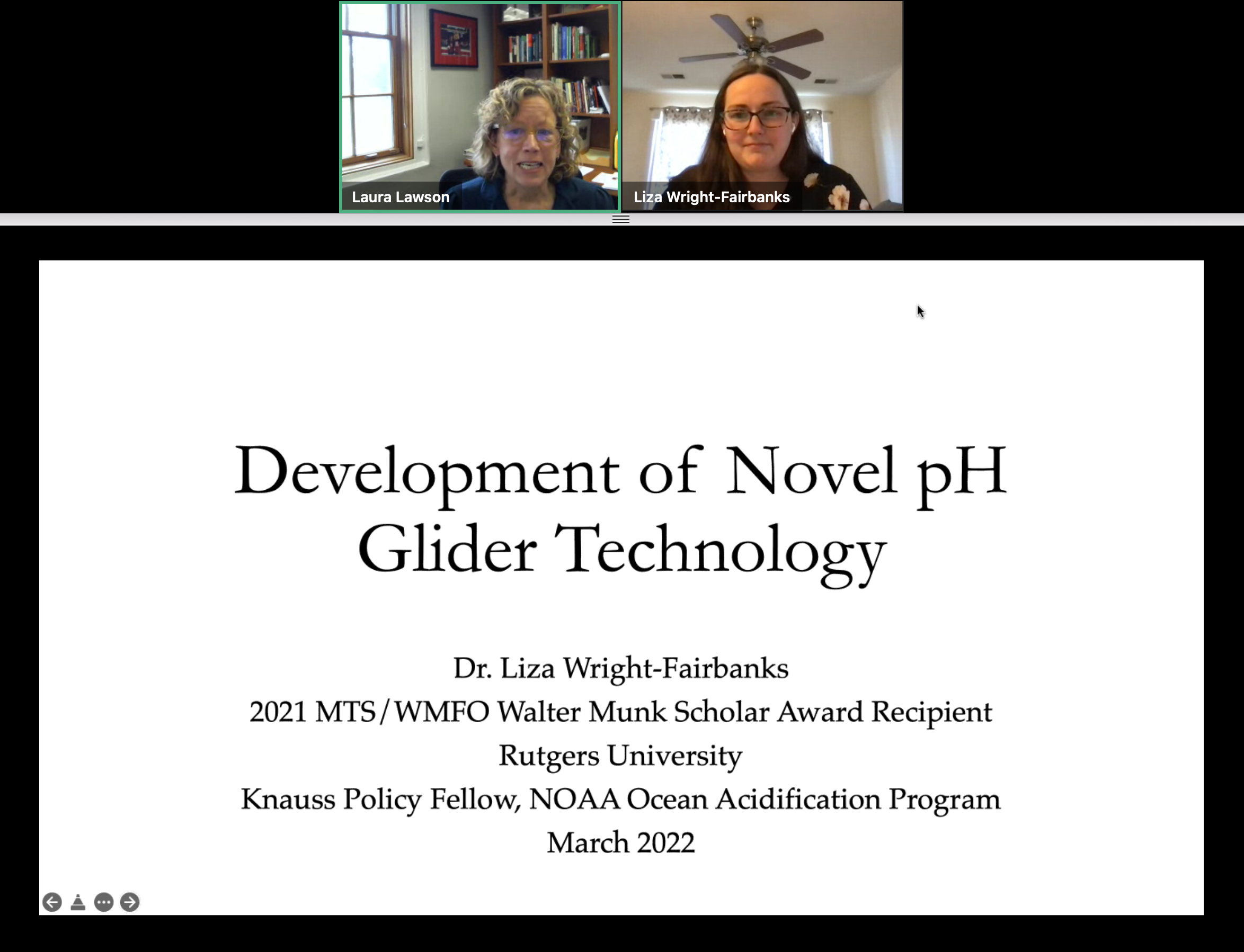
RUCOOL has been delivering real-time imagery to its website since 1994. This month we are introducing a new faster and easier to use viewer for all new and archived imagery, which is located here. Not only has the front end GUI been updated, but so have the images themselves. The new images have higher resolution detail throughout all of the 23 sea surface temperature geographic areas. Through the fall of 2020, we will continue to generate both the new and old imagery, as well as maintain the both the new GUI and the existing pages here. Once the northeast US fishing and beach season concludes later this year, we will take down the old site and stop producing the older imagery format. Additionally, we wanted to make you aware of the Mid-Atlantic Regional Association Coastal ocean Observation System’s (MARACOOS) OceansMap viewer. This state-of-the-art interactive system not only has the capability to display satellite data, but also data from over 100 different sources, including hurricane tracks, winds, currents, forecasts, station and buoy locations. Users can interact with the map clicking to see the latest temps, wind speeds, wave heights, etc. RUCOOL is proud to be part of the MARACOOS team. We thank the thousands of you that have used our data over the last quarter of a century, and look forward to providing you satellite imagery and ocean data for years to come.

The Ocean and Coastal Observing –Virgin Islands (OCOVI) team that is part of the Caribbean Coastal Ocean Observing System (CARICOOS), partnered up with RUCOOL to deploy the RU29 glider hurricane hunter just south of St. Thomas this week. Video of the deployment can be viewed here. Data from this glider is available here. The goal of these types of glider deployments is to improve understanding of the rapid co-evolution of the ocean and atmosphere as hurricanes approach landfall, affecting the storm’s intensity.  Continued advances in hurricane science, leading to increased forecast accuracy and lead times, is required to promote more timely and effective hurricane responses that save lives, property and livelihoods. We thank Vetelsen Foundation for supporting this important research.

Travel down to the West Antarctic Peninsula, one of the fastest warming locations on Earth. The rising temperatures are decreasing the amount of sea ice present and changes are now rippling through the food web. We discuss the findings of a 30-year effort to document the changing ecology of this region and reflect on how it provides a picture of the future of polar regions on our warming planet. Oscar Schofield, Professor of Marine and Coastal Sciences presenting. This event is sponsored by the SEBS Office of Academic Programs and the SEBS Office of Alumni and Community Engagement. When Tuesday, September 22, 2020 11:30 AM – 12:30 PM Original article from SEBS

Congratulations to Joe Anarumo who successfully presented his Masters work on Wednesday. Joe is a member of the first cohort of the Operational Oceanography masters program. During his time in DMCS Joe became an expert in using open-source drifter simulation code. His thesis plugged local observational resources into the drifter simulation code OpenDrift to create an easy to use tool for tracking things floating in the mid-Atlantic bight. His thesis, “An Open-Source Software Application for Drifter Trajectory Prediction in the Mid-Atlantic Bight” has been submitted for presentation at the Marine Technology Society annual conference. Joe will bring his data skills to his new role as an Environmental Science Analyst at Sage Services where he will help run data analysis for the Water Quality Compliance Modeling Program for the watershed of Philadelphia. Congrats Joe!!

Congratulations to Julia Engdahl who successfully defended her Masters thesis! Part of the first cohort of DMCS’ new program in Operational Oceanography, Julia has developed deep expertise in observing systems and cutting edge ocean data processing. Her thesis developed and tested algorithmic and machine learning approaches to analyzing underwater video. This work, “Developing an automated analysis of fish migration video using computer vision algorithms”, has been submitted to the Marine Technology Society OCEANS conference. Julia will put her degree to work in her new role as an Oceanographic Data Specialist at Lynker Technologies, where she will process and analyze water level and current data for NOAA’s Center for Operational Oceanographic Products and Services. Congrats Julia!

Torpedo shaped machines known as Slocum ocean gliders travel anywhere from the ocean’s surface to more than 3,000 feet underwater, collecting critical data that not only improves forecasts but will ultimately help mitigate the damage and destruction from hurricanes. “Hurricanes since 1980 have accounted for about $870 billion in damage, about 6.5 thousand deaths,” said Gerhard Kuska, the Executive Director of MARACOOS. “That’s actually over 50-percent of all the billion-dollar disasters.” Full article and video (mouse over video and unmute for sound) at NBC CT

Two weeks. That is the amount of time Janice McDonnell and Sage Lichtenwalner, Co-PIs of the OOI Ocean Data Lab Project, had to create an eight-week intensive, hands-on virtual program for Research Experience for Undergraduates (REU) students, who couldn’t attend their original programs due to COVID-19 restrictions. McDonnell and Lichtenwalner jumped in with both feet and successfully pulled together a program for 16 undergrads from 16 institutions that will wrap up on July 31st. Not only did they have to develop a curriculum in short order, they recruited 17 mentors, who provided one-on-one mentoring for each of the REU students. Full article at Ocean Observatories Initiative