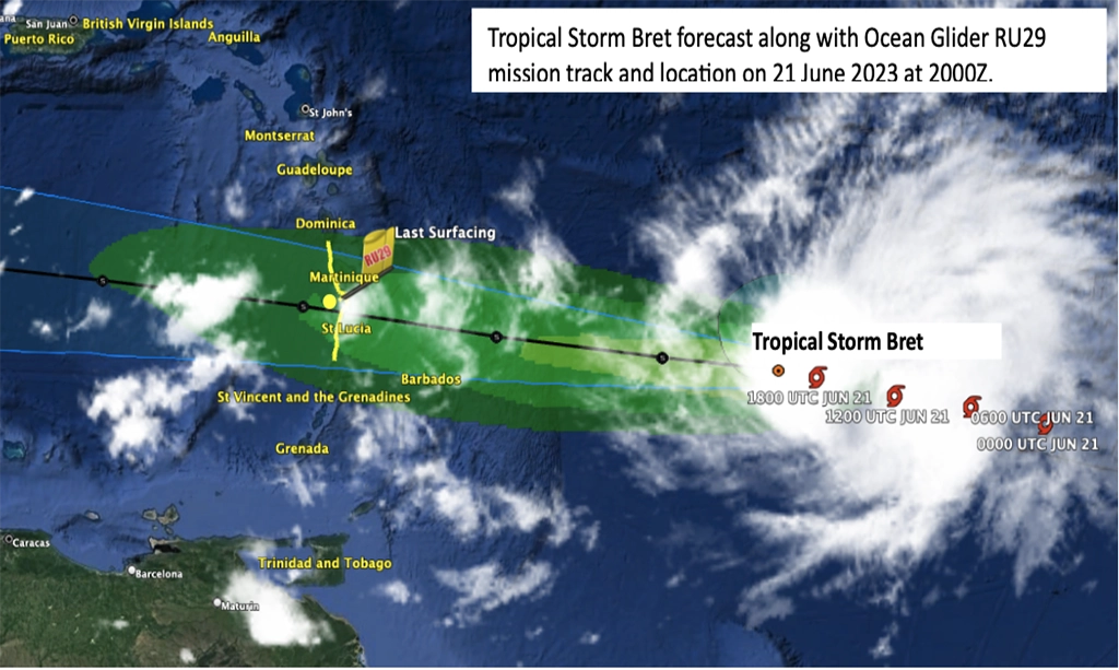
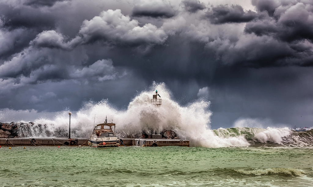
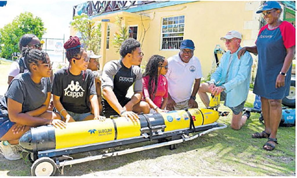
In early July, the Caribbean experienced 165 mph winds as Category 5 Hurricane Beryl swept through the region. Beryl was unprecedented, becoming the Atlantic’s earliest forming Category 5 tropical cyclone on record. The storm developed and rapidly intensified to maximum wind speed in less than four days – a behavior uncommon this early in the season. Despite the unprecedented intensification, hurricane scientists and oceanographers with NOAA were prepared. Researchers collaborated with multiple partners to sample Beryl from top to bottom, providing invaluable data to safeguard life and property while also aiding future research to unlock complex tropical cyclone processes. Hurricane Research Division scientists photographs the “stadium effect” within the eye of category 5 hurricane Beryl from aboard the NOAA Hurricane Hunter P3 Orion. To better understand Hurricane Beryl, scientists observed the storm from the sea, sky, and space with an array of observational instruments to gain a comprehensive perspective of the storm’s behavior and dynamics. Data from these instruments were assimilated into weather models and used by the National Hurricane Center for more accurate track and intensity forecasts. Ocean temperature and salinity features influence a hurricane’s ability to pull deeper waters upward that cool the surface ocean, an interaction known to impact storm development and intensity. An underwater glider deployed by Rutgers University’s Center for Ocean Observing Leadership, RU29, was near Beryl’s projected path and, as Beryl approached, was moved to inside the forecast cone. Soon after, the storm crossed directly over the glider, collecting measurements below the hurricane’s eyewall. This is believed to be the first time a glider has been beneath the eyewall of a category-5 hurricane. As the glider made frequent dives to depths over 1500 feet, unprecedented data revealed how Beryl mixed, cooled, and changed the ocean below. The data were submitted in real-time to the U.S. IOOS National Glider Data Assembly Center for immediate use in forecast models as well as research. Full article at NOAA Research

The Global Ocean Monitoring and Observing Program (GOMO) received funding through the Disaster Relief Supplemental Appropriations Act to support a focused ocean-atmosphere observing experiment during the 2023 hurricane season. This research experiment, called the Coordinated Hurricane Atmosphere-Ocean Sampling (CHAOS) is an integrated field campaign led by GOMO’s new Extreme Events Program and conducted as part of NOAA’s Atlantic Oceanographic and Meteorological Laboratory’s long standing Hurricane Field Program. The goal of CHAOS is to improve our understanding of the role of the ocean, waves, and air-sea interactions in the development and intensification of hurricanes in order to produce more accurate and reliable models and forecasts. To support the development of early career scientists and researchers, GOMO prioritized funding projects co-led by early career scientists, investigators and collaborators. Early career ocean professionals are defined as people who are current graduate students, postdoctoral researchers, or within 10 years since the completion of their highest graduate degree. Read more about the early career researchers involved in this collaborative effort below! Original article at NOAA Global Ocean Monitoring & Observing

Gov. Kathy Hochul suspended swimming at three Long Island state beaches as rough surf and rip tides and flooding as the effects of faraway storms continue to hit the region. New York City officials also issued a coastal flood advisory and warned that life-threatening rip currents could be present through Thursday. The Parks Department advised against swimming in areas without lifeguards, but an agency spokesperson said late Wednesday afternoon that city beaches would remain open to swimming. “We are continuing to monitor the forecast and currents, and will take appropriate action as necessary,” NYC Parks senior press officer Dan Kastanis said via email. But weather officials said they were hopeful the waters will calm in time for Labor Day weekend. The choppy waves are due to hurricanes Franklin and Idalia — even though neither storm is due to come within 500 miles of New York waterways. Franklin rapidly intensified into a Category 4 hurricane on Monday, as the cyclone churned its way from the tropics into the North Atlantic. Hurricane Idalia trailed not too far behind, making landfall as a Category 3 on Florida’s panhandle Wednesday morning. It’s due to travel through The South and then exit due east over the Carolinas. Despite their distance, both storms are creating swell waves — giant rolling masses of water that can travel long distances. Josh Kohut, a Rutgers University professor who studies physical oceanography, said these swells tend to get measured in two ways. First, there is the height or amplitude — the distance between the trough of the wave and its crest. The closer you are to the center of the storm, the higher the waves are going to be. “The other measure we take is the wave period. That’s how much time it takes to go from one crest to the next crest,” Kohut said. Swells tend to have longer periods — meaning more time passes before each one hits shore. Kohut said if beachgoers sit in the sand and count 10 seconds or more between the arriving waves, then they are witnessing swells. Smaller waves generated locally by the breeze tend to arrive about five seconds apart. Full article at Gothamist Photo credit: Michael M. Santiago/Getty Images

Ocean Glider RU29, belonging to Rutgers University, is stationed in the passage between St. Lucia and Martinique awaiting the arrival of Tropical Storm Bret. The glider has been carrying out a mission to improve ocean models for hurricane forecasting and study heat and fresh water transport in the region around the Windward Islands. It is part of the International Challenger Glider Mission sponsored by the G. Unger Vetlesen Foundation with ocean scientists from Rutgers University and the University of the Virgin Islands. The glider was launched off Martinique on May 30 by collaborators at the French Office of Biodiversity and the Parc Naturel Marin de Martinique and has been collecting data under Marine Science Research agreements in Martinique, Dominica, St. Lucia, and St. Vincent. The glider collects up to eight 1000-meter-deep profiles of ocean Temperature, Salinity, and Dissolved Oxygen concentration daily, and transmits them via satellite to the World Meteorological Organization’s Global Telecommunications System, where they can be immediately assimilated into the ocean models used in making hurricane forecasts. The upper ocean temperature and salinity structure and ocean heat content are all major factors in hurricane intensification, and having up-to-date measurements of them along a storm’s path is extremely valuable to accurate forecasts. These missions and their contribution to regional safety are possible through the cooperation of all the nations providing scientific research clearances for ac<vi<es like these. This mission is scheduled to continue through 26 June, and will be followed by another later in the 2023 hurricane season. Additional 2023 hurricane glider observations in the western Atlantic and Caribbean region will be supported by US NOAA and partners. Several regional projects supported by the UN Decade of Ocean Science for Sustainable Development are developing plans for operational glider measurements throughout the region.

Lessons learned from ocean observations during hurricanes Irene and Sandy pushed the U.S. to deploy a fleet of underwater robots during every hurricane season. As extreme weather events are becoming more frequent due to climate change, is it time to expand this hurricane forecasting capacity to other regions? 11 years after Hurricane Sandy hit the Caribbean islands and the East Coast of the United States in 2012, its destructive power is undoubtedly still vivid in the memories of its witnesses. The largest Atlantic hurricane on record, Sandy killed 233 people across the Caribbean and North America, and brought destruction with extreme winds, mudslides and flooding that inflicted almost US $70 billion in damage. “Just one year before that, we had Hurricane Irene, which was supposed to be a devastating storm – but then it kind of fizzled out. The next year, when alerts about Hurricane Sandy came up, people remembered Irene, and it was really difficult to convince anyone that this time it was going to be much bigger,” Dr Scott Glenn, distinguished professor at Rutgers University shares his memories. What he knew that the weather forecasters did not, was the alarming conditions below the ocean surface that warned the hurricane would be extremely powerful. “When hurricanes Irene and Sandy hit, we had our underwater gliders – autonomous underwater vehicles that collect ocean observations, and they were deployed during both of these events. And right before Irene arrived, we saw the ocean cool very rapidly,” says Dr Glenn. “This cooling just pulled the energy out of the storm and rapidly weakened it. But there was no such cooling before Sandy, and so the heat would only fuel the storm.” The ocean controls our planet’s water cycle, and even small changes within it can have a big impact on weather events on land. Such different ocean conditions observed before Hurricane Sandy raised serious concerns between scientists, including Dr Glenn himself, who quickly understood that this time the hurricane was not going to show any mercy. But surprising though it may seem today, 11 years ago weather forecasts were not automatically absorbing ocean data into their models. “I had this data from the gliders in the ocean, but at that time there was no way for me to communicate this. There was no way to add it to the information stream that reaches the forecasters,” he says. Since then, Dr Glenn and other oceanographers have worked hard to raise the importance of ocean observations in extreme event forecasting and to develop an operational system for data collection in the path of storms. Today the U.S. boasts a full hurricane glider fleet deployed during every hurricane season. These sturdy underwater robots can withstand destructive weather conditions in order to collect and transmit near real-time ocean data into the U.S. Integrated Ocean Observing System (IOOS), a part of the Global Ocean Observing System (GOOS). Since 2018, this data is included into hurricane forecast models, contributing to timely and more accurate warnings. Full article at GOOS

Travis Miles, Professor of Marine and Coastal Sciences at Rutgers University, explains how ocean robots, known as gliders, have improved the accuracy of forecasts. Full video at Fox Weather

Researchers continue to advance hurricane science, leading to increased forecast accuracy and lead times As Superstorm Sandy approached the New Jersey coastline, a single Rutgers glider deployed off Tuckerton by hurricane scientists at Rutgers University Center for Ocean Observing Leadership, provided an ominous warning. The water mass known as the “Mid Atlantic cold pool”– an area of cool water off the coast that traditionally makes hurricanes less severe the further north they travel — mysteriously vanished from the New Jersey coast, eliminating one of state’s natural defenses against hurricanes. What followed was the second costliest tropical cyclone to impact the United States, which resulted in numerous lives lost because of Sandy’s high winds and catastrophic storm surges. The storm caused about $30 billion dollars’ worth of damage throughout New Jersey. Four days before Sandy made landfall, Travis Miles, then a doctoral degree student and now assistant professor of marine and coastal sciences, traveled 13 miles off the coast in rough seas to launch Glider RU23 – an ocean robot that can acquire data in the waves at the center of a hurricane and studies tropical storm intensification and ocean acidification, water temperature, depth, salinity and more – near the Rutgers University Marine Field Station. It was one of the first planned missions of its kind. Over the past decade, Rutgers robot research has helped change the field of oceanography and the way scientists understand extreme weather. In the last two weeks, gliders have been collecting information about Hurricane Ian off the coast of New Jersey as the storm traveled north after devastating parts of Florida. “As we watched Superstorm Sandy in 2012, it became more apparent it wasn’t weakening, at least not due to the ocean, the way Hurricane Irene did,” said Miles, a former graduate student of RU COOL cofounder Scott Glenn, who has been an integral part in developing a new generation of oceanographers. “All of the cold water we expected, similar to the year before, to weaken the storm wasn’t there. So we knew we had to track it.” Full article at Rutgers News