


-
Two storms approach the Gulf
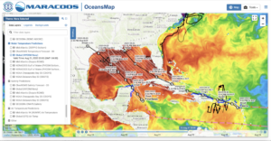
Posted on August 21st, 2020 No commentsTwo tropical storms are approaching the Gulf of Mexico. Tropical Storm Laura is currently over the Caribbean’s Windward Islands and is forecast to travel along the Greater Antilles along the cooler northern side of the Islands and into the very warm Sea Surface Temperatures (SST) of the Gulf were it is expected to intensify into a hurricane. Fourteen is moving northward over the warm waters of the western Caribbean towards Yucatan, then into the very warm Gulf where it is expected to intensify to a hurricane. By Tuesday next week we could have 2 hurricanes intensifying in the Gulf and about to be making landfall along the northern Gulf Coast. The very warm ocean features of the Gulf will be something to watch over the next few days. Here we are looking at the general ocean features in the Navy’s data assimilative Global Ocean Forecast System (GOFS), the start of the value chain for 3 US coupled hurricane forecast models, the operational HWRF and HMON as well as the experimental HAFS with the new FV3 core. The temperature range of the SST color bar is 25C to 31C.
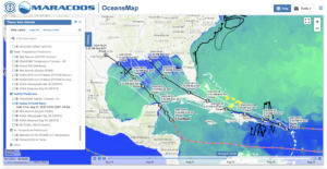
In parallel, we also watch for the low salinity barrier layers due to freshwater inputs from rivers. They are viewed below in the Sea Surface Salinity (SSS) fields also derived from the data assimilative GOFS. We see the fresh water barrier layers in the eastern Caribbean due to the Amazon and Orinoco, and the fresh water spread along the northern Gulf from the Mississippi. Here the color bar range is for salinities from 34 to 37.
So two storms entering the Gulf this weekend, both expected to intensify into hurricanes over the Gulf’s warm water early in the week, and both will be passing over the Mississippi’s freshwater barrier layers
Last 5 posts by Scott Glenn
- Early Season in the Mid Atlantic - June 17th, 2021
- Disturbance in the Gulf - June 16th, 2021
- Hurricane Gliders 2021 - May 3rd, 2021
- Hurricane Iota - November 16th, 2020
- Hurricane Eta - Low Wind Shear, High SST - November 2nd, 2020
