


-
Laura and the Loop
Posted on August 22nd, 2020 No commentsThe NHC forecast discussion from this morning nicely summaries the expectations for Tropical Storm Laura as at moves into the Gulf of Mexico over the weekend. The intensity forecast approaching the Gulf is highly track dependent. If the track is mostly Hispaniola and Cuba, the rugged terrain favors keeping the intensity low. If the track is more over the water, the warm ocean favors an earlier increase in intensity. The larger intensity uncertainty occurs when Laura enters the Gulf.
For the operational models in the Gulf, HWRF track is more to the east, landfalling in MS and has a significant intensity increase to Cat 4 crossing the Gulf. HMON has a track more to the west and keeps the intensity relatively steady below Cat 1 until approaching landfall in TX. The new experimental HAFS model favors a track similar to HMON but with an intensity that never increases beyond tropical storm.
https://www.emc.ncep.noaa.gov/gc_wmb/vxt/HMON/tcall.php
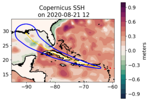
It has been a season for science storms. What this storm does after it enters the Gulf will be a test case for future model improvements. Part of those studies will be to better understand the impact of the ocean on intensity. As Laura enters the Gulf, it will be crossing the Gulf’s most significant Essential Ocean Feature for hurricane intensity, the Loop Current. We start with a look at the Loop Current state in the two data assimilative global ocean models, the Navy GOFS and European Copernicus. Maps of Sea Surface Height (SSH) are plotted below from both models.
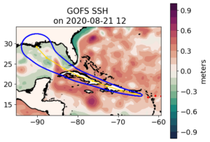
In the figure above and below, the Loop Current is high (red) sea surface height area that enters the Gulf between Yucatan and Cuba and then leaves the Gulf between Florida and Cuba. Comparing the two models we see the Loop Current position is very similar, with some slight variations in the east-west width. The models also agree that there is warm eddy north of the Loop Current and just south of Mississippi that will likely play a role in the intensity forecasts. We see the eastern path of Laura towards MS is near this warm water feature, while the western path towards TX is over more cold water (low SSH in green) features until you approach the coast of TX, when HMON says the storm could intensify.
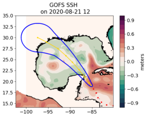
In one more plot, that warm eddy we looked at during Cristobal that was along 90W. It is now in the western Gulf centered around 94W. It is shown in the GOFS SSH plot below and is to the west of the forecast track cone for Marco.
Looks like the focal points for the oceanographers for these storms will be the details of the Loop Current shape and the warm eddy south of Mississippi.
