


-
TS Arthur tracks along the Gulf Stream
Posted on May 19th, 2020 No commentsBelow is the view of Tropical Storm Arthur in the MARACOOS OceansMap. https://oceansmap.maracoos.org/
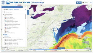
The track of Arthur follows the warm water of the Gulf Stream observed in the satellite SST. Arthur is forecast to now turn more towards the south. Arthur tracked close to 2 gliders that were flying in the Gulf Stream, Silbo operated by TWR and a spray glider operated by WHOI. Silbo in black is shown leaving the Gulf Stream to the north while the Spray glider in gray continues west with the Stream. Currents from the MARACOOS HF Radar network on the Mid Atlantic shelf are strong and alongshore towards the south.

A quick look at the global model temperature profiles as Glider Silbo leaves the Gulf Stream looks like a much faster departure in the models than in the real world. We’ll look more at the slope sea comparison when the glider is out of the Stream in both the model and real world conditions. Plots from all the gliders can be viewed at https://rucool.marine.rutgers.edu/hurricane/Hurricane_season_2020/
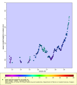
NHC warnings included heavy surf along the Mid Atlantic coast from Arthur. Some of the HF Radar systems in the Mid Atlantic are set up to monitor waves in real time and send the data to the NWS forecast offices. Above is one example of HF Radar derived waves along the NJ coast at Seaside Park, the first site to break 3 m. Waves from the NDBC sites further offshore are approaching 9 ft. The full HF Radar waves dataset can be accessed at
https://marine.rutgers.edu/~hroarty/maracoos/ERDDAP_MAB_HFR_Wave_Data_v2.html
-
TS Arthur forecast to turn just south of the gliders
Posted on May 18th, 2020 No comments
Tropical Storm Arthur is forecast to move parallel to the North Carolina coast today. The morning forecast discussion from the National Hurricane Center indicates that “Arthur is moving near and almost parallel to the Gulf Stream”. Several gliders are deployed in the slope sea or Gulf Stream just north of the forecast track, with glider Silbo being in the most southern position.

In the above figure temperature profiles from the global models are compared to glider Silbo. Profiles from the U.S. data assimilative GOFS and the operational RTOFS have similar features and agree well above 400 m and below 800 m. The transition between the 18C water near 300 m depth and the 7C water near 800 m depth is often related to differences in the position of the Gulf Stream. The global model from Copernicus starts near the same surface temperature, likely due to similar satellite Sea Surface Temperatures being assimilated, and is similar in the deep water at 1000 m, but what happens in between is has a very different shape.
-
New 2020 Ocean Forecast Workflow for Hurricanes
Posted on May 15th, 2020 No comments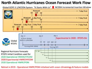
There are 3 steps in the workflow for the ocean component of NOAA’s operational hurricane forecast models HMON and HWRF.
Step 1 is data assimilation. This is accomplished by the Navy using the Global Ocean Forecast System (GOFS) version 3.1. The data is assimilated using the Navy Couple Ocean Data Assimilation (NCODA) system. Data from each day is typically inserted over a 3 hour insertion window running from 9Z to 12Z each day. Major datasets for assimilation include satellite Sea Surface Temperature (SST), satellite sea surface height from altimeters, data from profiling instruments like Argo and underwater gliders, etc.
Step 2 is to layer on the NOAA global windfield from GFS. Here the NOAA global Real Time Ocean Forecast System (RTOFS), starting at day 0, looks back 2 days and extracts from GOFS 3.1 its initial condition (IC). That initial condition is then run forward back up to day 0 without data assimilation with forcing from the EMC GDAS. Then on day 0, the wind forcing is switch to GFS to run RTOFS for several days into the future. Starting in August 2020, it is anticipated that and experimental version of RTOFS Data Assimilation (RTOFS-DA) will be run. Thus there are 3 US global ocean models to compare to observations this coming hurricane season – operational GOFS3.1 with NCODA, operational ROTFS without data assimilation, and experimental RTOFS with RTOFS-DA. We hope to expand this to include the European global ocean forecast system available through Copernicus.
Step 3 is to extract initial conditions (IC) and Boundary Conditions (BC) from RTOFS every 6 hours to initialize the regional ocean models that are coupled to the atmospheric forecast models HMON and HWRF. The operational HMON atmospheric model is coupled to a regional HYCOM ocean model. The HWRF atmospheric model is coupled to both HYCOM and POM ocean models. It is anticipated that for the 2020 hurricane season, the operational HWRF will be coupled to POM, and an experimental HWRF will be coupled to HYCOM. This makes at least 3 different oceans that will be present under hurricanes this season. The commonality in 2020 is that all 3 oceans will start from the same initial condition provided by ROTFS every 6 hours. The difference will be what ocean model and what windfield is used to evolve the initial conditions, and how much difference that makes during the storm forecast.
-
RUCOOL Updates: February to March, 2020
Posted on May 15th, 2020 No commentsDespite the COVID-19, RUCOOL remains active and excelling. Core technologies (storm gliders and HF Radar) were deemed critical research tools based on national security requirements and continue to be supported. These activities are guided by an operations plan that maintains recommended self-distancing practices. In fact, RUCOOL has developed standard operating procedures for glider deployments leveraging social distancing requirements, which have been shared with multiple funding agencies and research partners. The operating guidelines are available upon request.
State
- In early April, the first operational oceanography Masters students will be submitting abstracts of their thesis to the Marine Technology Society OCEANS meeting. One of the Masters students has already accepted a job working for NOAA’s operational oceanography service following her degree.
- RUCOOL initiated two projects with Atlantic Shores Offshore Wind, the joint NJ offshore wind project between EDF Renewables and Shell New Energies. One project is installing a vertically pointing wind lidar at the Rutgers Marine Field Station. The second is a modeling study of visibility conditions along the NJ coast.
- RUCOOL hosted Commissioner Dianne Solomon of the New Jersey Board of Public Utilities for a tour and discussion of offshore wind.
- In March, 4-H launched a Virtual 4-H at Home Short Term Exploratory Program (STEP). The program was entitled: Exploring Life in the Southern Ocean and consisted of three 1.5 hour classes geared towards 5th-8th grade students – see https://4hset.rutgers.edu/online-learning/. Young people from across the state participated in this inaugural program led by the RUCOOL education team.
- To fill the gap of in person 4-H STEM learning due to COVID-19, the RUCOOL education team has joined a larger Rutgers group that has created a new 4-H STEM Blog to help kids connect to STEM activities from home: https://4hset.rutgers.edu/stem-blog/.
National
- Grace Saba presented an invited to Sea-Bird Scientific on the glider pH efforts and path forward for an industry-academic partnership. Grace runs the only two pH gliders in the world.
- The RUCOOL Education and Science teams lead the authoring of a special issue for the National Marine Educators Association Journal called Current – https://polar-ice.org/nmea_current/https://polar-ice.org/nmea_current/
- Hugh Roarty travelled to Vessel Traffic Service (VTS) Centers around the United States (Port of New York, Houston, Louisville and Port Arthur) to evaluate the Coast Guard use of HF radar to manage traffic in the ports. Existing microwave radars operated by the United States Coast Guard (USCG) do not provide reliable detection of small vessels. Hugh will meet with Coast Guard personnel at the twelve MORE VTS centers and develop a needs analysis with respect to radar remote sensing.
- For the NASEM HF-Radar work in the Gulf of Mexico, RUCOOL is improving CODAR ship detection software. Tests are being performed by comparing data acquired near two oil platforms in the Gulf of Mexico and from the Sandy Hook NJ site, to the national Automated Identification System (AIS) ship tracking data.
International
- RU COOL scientists working on the NSF-funded Palmer LTER and Project SWARM connected with thousands of K-12 students this past winter in 10 live video teleconferences (VTCs) from Palmer Station, Antarctica. The education team recruited and prepared 25 teachers from 21 schools in 11 states (NJ, DE, NY, CT, VA, FL, AL, MN, AZ, OR, CA), reaching 1060 students directly and many more via the call recordings that are shared online. The interaction helps build science identity as reported by teachers.
- Several members of the RUCOOL team attended the Ocean Sciences meeting in San Diego in late February, which is the world’s largest oceanography conference, delivering 20 presentations (many are available on our website). Grace Saba co-chaired the town hall on Exploration of the Twilight Zone Ocean Network (JETZON), which published a piece in Nature last week
- The RUCOOL team collected data for the last 30 years as part of the NSF funded Palmer Long Term Ecological Research program, that is conducting a long term study of how a changing climate will impact polar marine ecosystems along the West Antarctic Peninsula (WAP). This year leadership of the Palmer LTER was transferred to Rutgers which is the principal institution running this multi-university long term effort.
- RUCOOL lead a team partnered with the University of Delaware, Oregon State University, Old Dominion University, Polar Oceans Research Group, and University of Alaska Fairbanks to deploy a polar ocean observatory off the coast of Antarctica. COVID-19 provided a challenge with travel logistics as scientists and students were scheduled to arrive home in late March. The entire team arrived home safely in late March, thanks to a great deal of help, cooperation and communication between gov’t agencies, airlines and universities. It’s good to have them back.
Student Awards
- Kasey Walsh, Grace Saba’s undergraduate student, received the Undergraduate Research Excellence Award from the Department of Marine & Coastal Sciences.
Newly Funded Research
- EDF Renewable 2020-2021, “Atlantic Shores Visibility Modeling Study” ($15,489), Joe Brodie.
- EDF Build 2020-2021, “RUMFS Atlantic Shores Lidar Deployment” ($68,885), Joe Brodie.
- Stevens Institute of Technology, Department of Homeland Security, “VTS Radar for Small Vessel Detection” ($192,473), Hugh Roarty.
- National Science Foundation 2020, “LTER Palmer, Antarctica (PAL): Land-Shelf-Ocean Connectivity, Ecosystem Resilience and Transformation in a Sea-Ice Influenced Pelagic Ecosystem”, ($1,134,426), Oscar Schofield.
- National Science Foundation 2020, “REU Site: Research Internships in Ocean Sciences (RIOS)”, ($498,502), Josh Kohut
Papers Published: (**Current or Former Graduate Student or Postdoctoral Researchers)
- Martin, A., Boyd, P., Buesseler, K., Cetinic, I., Claustre, H., Giering, S., Henson, S., Irigoien, X., Kriest, I., Memery, L., Robinson, , Saba,G., Sanders, R., Siegel, D., Alfageme, M.V., Guidi, L. 2020. Study the twilight zone before it is too late. Nature 580: 26-28, DOI: 10.1038/d41586-020-00915-7
- Hunter-Thomson, K., Kohut, J., Saba, G.Empowering Students with Polar Science Through Real World Data. Current: The Journal of Marine Education 34(1): 13-18.
- Greengrove, C., Lichtenwalner, H. Palevsky, A. Pfeiffer-Herbert, S. Severmann, D. Soule, S. Murphy, L. Smith, and K. Yarincik (2020), Using Authentic Data from NSF’s Ocean Observatories Initiative in Undergraduate Teaching: An Invitation, Oceanography, 33(1), DOI:10.5670/oceanog.2020.103.
- Ferraro, C., Jordan, R., Kopp, R. E., Bond, S. L., Gong, J., Andrews, C. J., Auermuller, L. M., Herb, J., & McDonnell, J.(2020). Training Students to Improve Coastal Resilience. In A. Zimmerman (Ed.), Preparing Students for Community-Engaged Scholarship in Higher Education (pp. 347-360). Hershey, PA: IGI Global. DOI:10.4018/978-1-7998-2208-0.ch017
- McDonnell, J., Hotaling, L., Schofield, O., Kohut, J.(2020). Key concepts in polar science: Coming to consensus on the essential polar literacy principles. Currents: Journal of Marine Education. 34(1): 2-8
- McDonnell, J., Schofield, O., Bean, C.Bringing long-term ecological research (LTER) at Palmer Station Antarctica to your classroom. Currents: Journal of Marine Education. 34(1): 15-17
RUCOOL Meetings & Conferences
AGU Ocean Sciences, San Diego, CA; Schmidt Foundation, San Diego, CA; IOOS Annual Meeting, Washington, DC; USCG Meetings at Port of New York, Houston, Louisville and Port Arthur, TX; Swam Research, Palmer Station, Antarctica; Rhode Island Parks Conference, Rhode Island; Tropical Cyclone Operations and Research Forum, Lakeland, FL.
RUCOOL Visitors
- Total number of visitors to RU COOL: 75 (Lab was shut down for tours on March 6 due to COVID-19)
