


-
New 2020 Ocean Forecast Workflow for Hurricanes
Posted on May 15th, 2020 No comments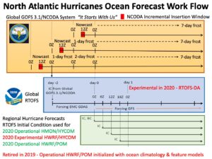
There are 3 steps in the workflow for the ocean component of NOAA’s operational hurricane forecast models HMON and HWRF.
Step 1 is data assimilation. This is accomplished by the Navy using the Global Ocean Forecast System (GOFS) version 3.1. The data is assimilated using the Navy Couple Ocean Data Assimilation (NCODA) system. Data from each day is typically inserted over a 3 hour insertion window running from 9Z to 12Z each day. Major datasets for assimilation include satellite Sea Surface Temperature (SST), satellite sea surface height from altimeters, data from profiling instruments like Argo and underwater gliders, etc.
Step 2 is to layer on the NOAA global windfield from GFS. Here the NOAA global Real Time Ocean Forecast System (RTOFS), starting at day 0, looks back 2 days and extracts from GOFS 3.1 its initial condition (IC). That initial condition is then run forward back up to day 0 without data assimilation with forcing from the EMC GDAS. Then on day 0, the wind forcing is switch to GFS to run RTOFS for several days into the future. Starting in August 2020, it is anticipated that and experimental version of RTOFS Data Assimilation (RTOFS-DA) will be run. Thus there are 3 US global ocean models to compare to observations this coming hurricane season – operational GOFS3.1 with NCODA, operational ROTFS without data assimilation, and experimental RTOFS with RTOFS-DA. We hope to expand this to include the European global ocean forecast system available through Copernicus.
Step 3 is to extract initial conditions (IC) and Boundary Conditions (BC) from RTOFS every 6 hours to initialize the regional ocean models that are coupled to the atmospheric forecast models HMON and HWRF. The operational HMON atmospheric model is coupled to a regional HYCOM ocean model. The HWRF atmospheric model is coupled to both HYCOM and POM ocean models. It is anticipated that for the 2020 hurricane season, the operational HWRF will be coupled to POM, and an experimental HWRF will be coupled to HYCOM. This makes at least 3 different oceans that will be present under hurricanes this season. The commonality in 2020 is that all 3 oceans will start from the same initial condition provided by ROTFS every 6 hours. The difference will be what ocean model and what windfield is used to evolve the initial conditions, and how much difference that makes during the storm forecast.
Last 5 posts by Scott Glenn
- Early Season in the Mid Atlantic - June 17th, 2021
- Disturbance in the Gulf - June 16th, 2021
- Hurricane Gliders 2021 - May 3rd, 2021
- Hurricane Iota - November 16th, 2020
- Hurricane Eta - Low Wind Shear, High SST - November 2nd, 2020
