


-
A milestone week for distributed autonomy
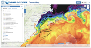
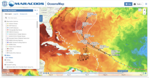
Posted on August 14th, 2020 No commentsJust a quick shot of Kyle off the Mid Atlantic from OceansMap. Kyle is forecast to hit the warm water in the many Gulf Stream meander crests as it travels northeast. Below that is a view of Josephine as it skirts the edge of the warm water on its path just east of the Caribbean’s Windward Islands toward our friends in Bermuda operating the BIOS gliders. Two tropical storms, but the significance for us will be looking at how the new version of HWRF performs in each.
Isaias was a grand success with hurricane gliders deployed along its entire track through the IOOS regions CARICOOS, SECOORA and MARACOOS.
A science storm. Strong enough to get our attention and motivating even broader collaborations with scientists from the Argo float, underwater Glider and surface drifter communities starting to coordinate their observations and science through NOAA OAR’s Ocean Observing for Extreme Events (OOEE) working group. But Isaias used the previous version of HWRF that did not benefit from the modern suite of data assimilative ocean models.
Josephine and Kyle are being forecast using the new version of HWRF, version 13.0.0, made operational by NWS on August 5 at 12Z. We have already seen some excellent new HWRF features like improved bathymetry and an initial ocean condition derived from the NOAA global RTOFS that, in turn, is derived from the data assimilative Navy GOFS model shown in the figures above. Josephine and Kyle are the first two storms where both operational hurricane models, HWRF and HMON, have an initial ocean condition that can trace its roots to a data-assimilative ocean model. For the first time we have complete end-to-end data flow from the Hurricane Glider Picket Line to both operational hurricane models. Construction of the value chain running from ocean data delivered by a distributed network of autonomous ocean gliders to inclusion in operational forecasts is now complete.
It took so many people, and a process we began in 2014, to deliver this week on the promise of distributed autonomy for hurricane forecasting. The Concept of Operations (the ConOps as we call it) for this is new. Different gliders on different missions operated by different groups funded for different purposes by different government agencies like NOAA, Navy, NSF, industry partners like Shell in the Gulf or Orsted in the Mid Atlantic, or foundations like Vetlesen in the Caribbean, all contributing their near real time quality-controlled data in standard formats through the IOOS Glider DAC so that it can be delivered via GTS to the global modeling centers for improved hurricane forecasts. We are a distributed team with so many collaborators from NOAA OAR, NOS and NWS, the Navy, IOOS and its North Atlantic hurricane-prone Regional Associations (MARACOOS, SECOORA, GCOOS and CARICOOS), industry partners (energy sector, data management, glider manufacturers, sensor manufacturers) and academics from the Caribbean to the Gulf of Mexico to the Gulf of Maine. We have dedicated time and effort to deliver the technology, the scientific justification, and the real time data streams we need to support improved forecasts for all. We have demonstrated that by engaging the many strengths of our distributed community, it can be done.
Work hard, have fun, change the world. Thank you Doug Webb for these words to live by.
Happy Friday All.
