


-
The night before …
Posted on August 25th, 2020 No commentsOur friends on the Texas-Louisiana coast are tonight preparing for a significant storm that will hit late tomorrow. Our job is to not to waste this event. Learn as much as we can when these terrible storms do happen so we can help provide more accurate guidance with longer lead time in the future.
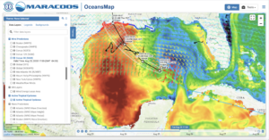
Lets look at the ocean conditions the night before. Here we look at the GOFS Sea Surface Temperature (satellite SSTs are obscured by the hurricanes clouds, so we need to look at the models). The most striking feature is the asymmetrical response of the Gulf to this storm that is not even half way across. Here the color bar ranges from 26C to 32C. The entire eastern Gulf has cooled to near 26C. The western Gulf is above average hot, closer to 31-32C. Laura is heading towards the warmer waters of the western Gulf. Also note that the intensification to Major Hurricane occurs just as the storm is making its way across the warm water on the LaTex shelf. Why is this storm forecast to intensify most over this piece of warm ocean? Is it so warm that the shallowness does not matter? Very happy to see what now have 3 gliders in play, two Navy Gliders, ng314 and ng645 in the direct forecast path, and TAMU glider Stommel just to the left.

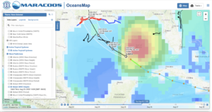
Lets next look at why the eastern Gulf is so much cooler. First we overlay the 5 km NAM winds over the SST, and we see the strongest winds on the right hand side of the Laura as it moves north.
Next pop up the global Wave Watch III waves and we see the largest waves 7 m high or higher are on same right hand side of the Laura as the strong winds. Lots of wind and large waves mean lots of mixing , and a cooler SST.
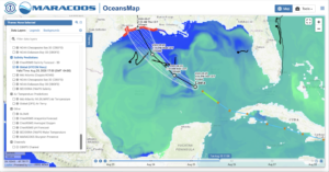
Laura has itself set up this east-west SST difference across the Gulf. But want about salinity, and the impact of Marco? Below is todays GOFS model Sea Surface Salinity (SSS), enhanced to highlight salinities between 34 and 37. Here fresh-salty water distinction is between the northern and the southern Gulf, with the northern coastal Gulf fresher than the regions around it. So the area we are forecasting for the largest intensification is the north west region of the Gulf where we have both the warm western waters and the fresher northern waters.
Last 5 posts by Scott Glenn
- Early Season in the Mid Atlantic - June 17th, 2021
- Disturbance in the Gulf - June 16th, 2021
- Hurricane Gliders 2021 - May 3rd, 2021
- Hurricane Iota - November 16th, 2020
- Hurricane Eta - Low Wind Shear, High SST - November 2nd, 2020
