


-
Ocean conditions for Marco and Laura
Posted on August 23rd, 2020 No commentsBoth Marco and Laura are forecast to intensify as they cross the Gulf and approach the coast of Louisiana. Lets check the ocean conditions they are encountering (Marco) or will encounter (Laura).
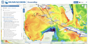
First we look at Sea Surface Temperature (SST) from the data assimilative Navy GOFS model. Here the temperature scale ranges from 25C to 32C. Marco is already over the Loop Current and Laura will pass over it. Both storms will be crossing over some of the warmest sea surface temperatures in the northern Gulf off the coast of Louisiana. A good contrast in what Marco will do to the deep warm waters of the Loop Current compared to the shallow warm waters of the northern Gulf before Laura passes over them.
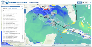
Below is the Sea Surface Salinity (SSS) map for the Gulf, with the color scale going from 34 to 37. The low surface salinity waters of the Mississippi River are evident on the Texas, Louisiana, Mississippi, Florida shelf. Our experience in the Caribbean during Isaias reminds us that the low salinity barrier layers inhibit mixing, resulting in less cooling of the surface waters, and greater potential to intensify the hurricanes.
Another natural experiment on the coupled ocean-atmosphere response to 2 hurricanes will unfold over the next few days. In our textbooks, we are told that the first hurricane is supposed to mix and cool the waters so the second hurricane has less warm water to promote intensification. But the warm water in the south is the deep Loop Current that does not cool rapidly. And the warm water is blanketed by a low salinity barrier layer that inhibits mixing. The storms will be passing by Navy Glider NG645 which has been on station this season as part of the annual Hurricane Glider Picket Line. Again, much more to learn if we form the research teams to look.
Last 5 posts by Scott Glenn
- Early Season in the Mid Atlantic - June 17th, 2021
- Disturbance in the Gulf - June 16th, 2021
- Hurricane Gliders 2021 - May 3rd, 2021
- Hurricane Iota - November 16th, 2020
- Hurricane Eta - Low Wind Shear, High SST - November 2nd, 2020
