


-
Leaning towards the regional models
Posted on August 24th, 2020 No commentsThe following is cut and pasted from the National Hurricane Center (NHC) Forecast Discussion at 5 am this morning:
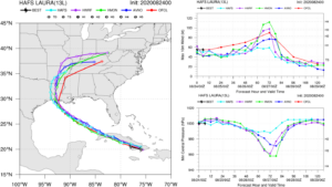
We also started a similar discussion in yesterday’s Hurricane Blog. The two operational regional models are continuing to agree this morning, and NHC may be leaning towards this consensus. Below is what this looks like from the NWS HAFS website. On the left, all the models are in tight agreement on the forecast track of Laura over Cuba, and across the Gulf up until landfall. On the upper right, the differences in the intensity forecast remain significant. The two regional models, HWRF (purple) and HMON (green), now using the same ocean initial condition derived from the data assimilative global GOFS model, still have Laura intensifying at 60 hours to a Cat 3 hurricane. One experimental model (light blue) is consistent with the consensus intensity of a tropical storm until 60 hours, but after 60 hours, instead of rapidly intensifying, keeps Laura as a weak tropical storm. The official intensity forecast from the NHC as described above is shown in red.
Last 5 posts by Scott Glenn
- Early Season in the Mid Atlantic - June 17th, 2021
- Disturbance in the Gulf - June 16th, 2021
- Hurricane Gliders 2021 - May 3rd, 2021
- Hurricane Iota - November 16th, 2020
- Hurricane Eta - Low Wind Shear, High SST - November 2nd, 2020
