


-
A good day for data assimilation
Posted on August 23rd, 2020 No commentsLet’s now look at Navy Glider NG645. Part of the annual Hurricane Glider Picket Line. The glider that is closest to the forecast track of Marco and Laura before the hurricane comes through.
Remember that the Hurricane Glider Picket Line has two purposes. The first purpose is to act in a coordinated fashion to resolve the Essential Ocean Features that impact hurricane intensity in each region that the hurricanes may pass over. This requirement to have a realistic ocean model forecast exists whether there is a hurricane or not, and benefits all users of the ocean model, including hurricane forecasters and models. The second purpose is to have at least one glider, and hopefully more, in place to witness the rapid evolution of the ocean as the hurricane passes. This provides data for the process and sensitivity studies that help improve the forecast models of the future. The two purposes have different sampling requirements, and the gliders have the flexibility for both.
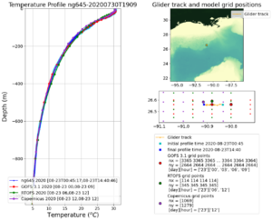
The first plot below is the temperature profiles provided by Navy Glider ng645 compared to the Navy global ocean model GOFS, the NOAA global ocean model RTOFS, and the European global ocean model Copernicus. My immediate impression is that the glider and the data assimilation schemes are doing their jobs. The daily spread in the glider profiles is nearly imperceptible, as is the difference between the US and European models. We see the surface layer of warm water above 26C is well less than 100 m deep, a shallow warm layer as expected based on the Sea Surface Height maps we looked in yesterday’s blog post. Our older textbooks say Marco will cool this layer through vertical mixing and leave a cooler ocean behind for Laura.
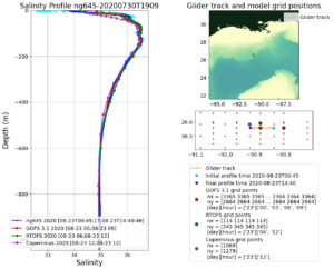
Now let’s look at salinity. Navy Glider ng645 daily salinity profile spread in light blue and the daily average in dark blue are compared to the three operational global models. Again, the differences are imperceptible. All the global models have a proper shape for the salinity profile, and even include a shallow fresh water barrier layer in the upper 40 m. The new textbook says this barrier layer is going to inhibit the mixing, so that Marco will not cool the ocean as much as expected, leaving behind a less cooled ocean for Laura. The Navy glider was out well before the storm, and there was plenty of time for the data to work its way through the system and into the models through the data assimilation system. The ocean model at the beginning of the hurricane forecast value chain, the Navy’s data assimilative GOFS model, could not be more ready. The Navy glider, and the Navy data assimilation into GOFS, is fulfilling the first purpose of the Hurricane Glider Picket Line as described above.
Tomorrow, and throughout the week, we watch Navy Glider ng645 fulfill the second purpose of the Hurricane Glider Picket Line to capture the rapid evolution of the ocean as two hurricanes pass over it.
Last 5 posts by Scott Glenn
- Early Season in the Mid Atlantic - June 17th, 2021
- Disturbance in the Gulf - June 16th, 2021
- Hurricane Gliders 2021 - May 3rd, 2021
- Hurricane Iota - November 16th, 2020
- Hurricane Eta - Low Wind Shear, High SST - November 2nd, 2020
