


-
One Ocean for Potential TS Nine
Posted on July 28th, 2020 No commentsIn terms of the ocean, we have never been more ready. Potential Tropical Storm Nine is crossing over the same ocean in all the forecast models.
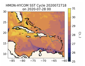
Here is SST from HMON’s HYCOM. This is part of the global GOFS to global RTOFS to regional HYCOM value chain.
We see the same features we talked about in the morning blog on the global models.
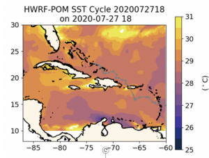
Here is the SST from HWRF that is coupled to MPIPOM. Focus on the Caribbean and along the track of the storm. The features are nearly the same. The cold water upwelled along the coast of South America is being advected around the Caribbean-wide anticyclonic feature south of Hispaniola in HMON and HWRF. The warmest water is up by Puerto Rico where AOML has the densest part of glider picket line in place well in advance. We saw in the morning blog that within that region covered by the gliders, the global models are all in really good agreement, telling us that even the different assimilation schemes appear to be bringing us closer together. The temperature ranges are so similar in these plots. All the US models are lining up in agreement on the basic Essential Ocean Features and temperature range before the storm, with the European Copernicus now representing a similarly structured but slightly warmer version of the ocean.
Much more to look at tonight. But from this initial look at the ocean side, we can’t be more ready.
Last 5 posts by Scott Glenn
- Early Season in the Mid Atlantic - June 17th, 2021
- Disturbance in the Gulf - June 16th, 2021
- Hurricane Gliders 2021 - May 3rd, 2021
- Hurricane Iota - November 16th, 2020
- Hurricane Eta - Low Wind Shear, High SST - November 2nd, 2020
