


-
Gonzalo over the Amazon-Orinoco Plume
Posted on July 24th, 2020 No commentsBelow we have the forecast track of Gonzalo across the Windward Islands and along the strong southern edge of the Amazon and Orinoco River plume. We look at how the fresh water from these river plumes is distributed in 3 operational global ocean models (GOFS, ROTFS and Copernicus) and the 2 operational hurricane models (HMON and HWRF).
First model is Navy Global Ocean Forecast System (GOFS 3.1). The forecast track of Gonzalo is black line with the dots at the forecast locations. A rare southern track along the Caribbean Corridor. The map is of the surface salinity. The plume meanders along the north coast of South American and then is wrapped around an anticyclonic (clockwise rotating) eddy just south of Hispaniola. The eddy covers the entire width of the Caribbean, so it is hard for a hurricane to miss it, and the anticyclonic motion means it has deep warm pool. Fresh water from the river plumes in the surface barrier layers further inhibit mixing by the hurricane as it passes over, reducing the amount of ocean cooling, which can effect intensity. Also not that the fresh water plume signal disappears about the location of the Nicaraguan Bank that runs from Nicaragua to Jamaica and on to Hispaniola. This structure for the freshwater is very similar to what Doug Wilson found in the climatology.

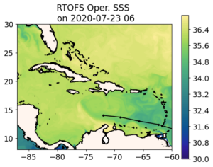
Now on to the NOAA Real Time Ocean Forecast System (RTOFS). Not much difference. RTOFS is derived from GOFS 3.1. The process was described in an earlier blog. Navy GOFS assimilates all the ocean data up to today, then RTOFS looks back 2 days in the GOFS model, pulls the 3-D GOFS fields as an initial condition, and the moves back up to the present and into the future with NOAA winds replacing the Navy winds. The trade off between 2 days of winds versus 2 days of assimilation looks less significant at this scale. RTOFS and GOFS SSS look about the same in terms of the features of interest, in this case, the location of the plumes.
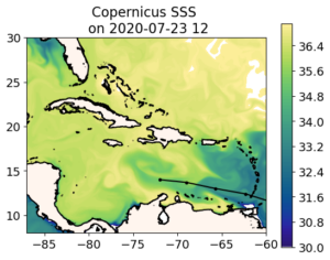
Now for the 3rd ocean model, the global European model in the Copernicus System. Now we see a much bigger difference. In particular, a much fresher Amazon-Orinoco Plume. The fresh water under the track of Gonzalo if fresher in the European model, and resulting a a more pronounced signature for the anticyclonic eddy. Maybe even more significantly, looking just west of the Windward Islands, in the place where AOML has the many gliders deployed around Puerto Rico, the European model is much fresher. This is something we can check out with the gliders. Which global model is doing better with the salinity of the barrier layers south of Puerto Rico.
 .
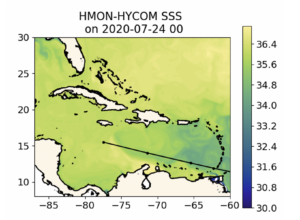
.Now we look at the regional ocean in the first operational hurricane model, HMON. This hurricane model is coupled to a regional version of HYCOM that gets its initial condition by pulling the 3-D fields from RTOFS. So it looks very much like RTOFS, which looks very much like the data assimilative Navy GOFS. All the same comments apply. Gonzalo is forecast to travel over the strong southern edge of the Amazon-Orinoco plume and eventually cross the warm eddy.
.
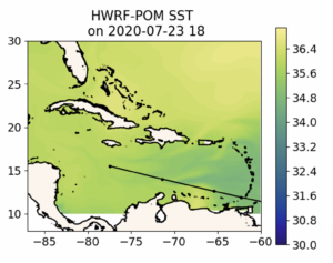
Lastly we look at HWRF. HWRF ins coupled to a regional version of the MPIPOM model that gets its initial condition from climatology modified by feature models for the Loop Current, the Gulf Stream, and some of the eddies. It appears that there is no anticylconic eddy added to the ocean model south of Hispaniola, and the Amazon-Orinoco plume is represented by climatology. This is a very different ocean. When we look at the differences between Navy GOFS (and RTOFS and HYCOM under HMON) with European Copernicus, we are debating the relative strength of the Essential Ocean Features like eddies and river plumes, and how different data assimilation schemes result in changes to these features. When we compare to MPIPOM under HWRF, we are debating if the same Essential Ocean Features even exist in the eyes of the hurricane.
Last 5 posts by Scott Glenn
- Early Season in the Mid Atlantic - June 17th, 2021
- Disturbance in the Gulf - June 16th, 2021
- Hurricane Gliders 2021 - May 3rd, 2021
- Hurricane Iota - November 16th, 2020
- Hurricane Eta - Low Wind Shear, High SST - November 2nd, 2020
