


-
Atlantic Shores Buoy off Atlantic City – 90% ahead of eye cooling
Posted on July 12th, 2020 No commentsFay continues to capture our attention with its ahead of eye cooling. Travis and I are now look at Fay using the Atlantic Shores buoy deployed in the Wind Energy Area off Atlantic City, NJ. This buoy is closer to landfall and south of the NDBC buoy in last night’s post. Atlantic Shores makes its buoy data available through the MARACOOS OceansMap, and you can download it as ERDDAP files. Here we look at it through the ERDDAP interface.
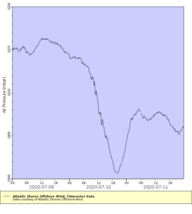
First plot is the air pressure. The minimum occurs at about 20 GMT on July 10. We will use this as the time of eye passage.
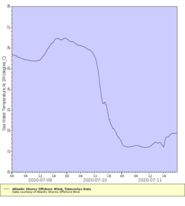
We now look at the ocean temperature from the sensor at 1 m depth below the surface. The water temperature cools from 26.5C before the storm to about 22C at eye passage at 20 GMT on July 10. Total of 4.5C cooling ahead of eye. The minimum temperature looks to be about 21.5C, so an additional 0.5C of cooling after eye passage. So for the total of 5C cooling caused by the passage of the storm, 90% occurs ahed of eye, and 10% after eye passage. Another good case for ahead of eye cooling and rapid co-evolution of the ocean and atmosphere.
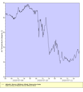
So how does this feedback on the atmosphere? Lets look at the air temperature from the Atlantic Shores buoy. Because of the rapid ocean cooling, the ocean is colder than air temperatures. The heat flux is from the hurricane into the ocean, which acts to weaken the storm. If our forecast had kept the ocean temperatures warm – a static ocean rather than a co-evolving ocean – the ocean would be warmer than the air temperatures, changing the sign of the heat flux and strengthening the storm.
This clearly demonstrates the value of IOOS collaborations between the Regional Associations, industry, and academic partners.
Last 5 posts by Scott Glenn
- Early Season in the Mid Atlantic - June 17th, 2021
- Disturbance in the Gulf - June 16th, 2021
- Hurricane Gliders 2021 - May 3rd, 2021
- Hurricane Iota - November 16th, 2020
- Hurricane Eta - Low Wind Shear, High SST - November 2nd, 2020
