-
Fay from a NDBC buoy – 2/3 ahead of eye cooling
Posted on July 11th, 2020 No commentsTropical Cyclone Fay shot up the Mid Atlantic Bight yesterday, making landfall around Atlantic City. Like an early season Irene (2011).
Irene is the famous storm where the MARACOOS ocean observatory, and its associated regional ocean and atmospheric forecast models, was used to identify the Essential Ocean Processes responsible for rapid ahead-of-eye cooling of the ocean, and the subsequent Rapid Weakening (RW) of the storm (see the paper linked in yesterday’s blog). The paper looked at over 130 atmospheric forecast sensitivity runs to discover that hurricane-forced ahead-of-eye ocean cooling was the critical missing physical process required to properly match the observed Rapid Weakening (RW) of Irene as it tracked through the Mid Atlantic. It’s a process we call rapid co-evolution of the atmosphere and ocean during the intense forced phased of a hurricane.
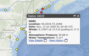
Looks like the best NDBC buoy to check for ahead of eye cooling is 44025, up in the Bight Apex.

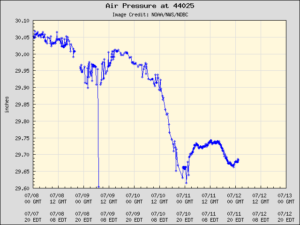
First we look at the atmospheric pressure. The minimum pressure is July 11, about 01 GMT.

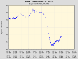
Now we look at the ocean temperature. Starts about 78F before the storm. At 01 GMT on July 11, the water temperature has cooled to about 72F, so 6 degrees F ahead of eye center cooling. The minimum temperature on 7/11 is about 69F, so 3F cooling after eye passage.

Result is 2/3 of the cooling ahead of eye, 1/3 of the cooling after eye passage. And this is for a buoy north of the landfall location. I would expect more cooling opportunity south of landfall. We’ll need to check the models for that.
How does this compare to the other Irene-class hurricanes that track across the Mid Atlantic? That same Nature Comms paper quoted yesterday has the table of all 11 Irene-class hurricane occurring between Charlie (1986) and Arthur (2014). The average percentage of ahead of eye cooling for these 11 hurricanes, based on the truly awesome 40 year NDBC buoy record, is 73%. And Fay is already at 66% ahead of eye cooling on our first look.
Physics is awesome. Thank you Adm. Lautenbacher.
Last 5 posts by Scott Glenn
- Early Season in the Mid Atlantic - June 17th, 2021
- Disturbance in the Gulf - June 16th, 2021
- Hurricane Gliders 2021 - May 3rd, 2021
- Hurricane Iota - November 16th, 2020
- Hurricane Eta - Low Wind Shear, High SST - November 2nd, 2020


