


-
Third Test – same answer
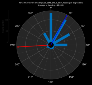
Posted on October 13th, 2018 No commentsWaypoint to west, with commanded heading in red towards 270 degrees. Average heading towards 30 degrees, or 120 degrees to the right of the commanded heading.
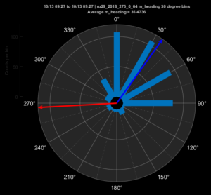
Glider moved in the direction of the averaging heading, towards the northeast. So no currents for third try, Copernicus (the currents shown here) is a clear winner.
We are 150 km from our intended pick up point just south of the shipping lanes. We are averaging 15 km/day. So 10 days from today, Oct 13, is Tuesday, Oct 23. Gives us a several day window for unexpected currents beyond that.
-
Second test – time to shift waypoint north
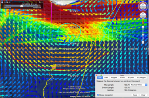
Posted on October 13th, 2018 No commentsThe heading rose plot from the last segment has an average heading 75 degrees to the right of the commanded heading. So we do not have an steady offset or trend. Sometimes the offset is less than 90 degrees to the right. Sometimes more. But it tends to oscillate around 90 degrees to the right of the commanded heading.
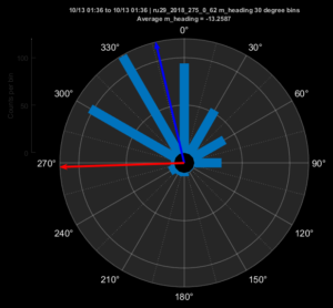
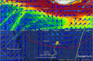
During this segment the glider moved to the northwest, in the direction of the average heading. So the currents are low. More evidence copernicus model is right. Copernicus currents are shown here.
So our plan is to continue sliding the waypoint north a little bit each day and walk this glider up to the edge of the shipping lanes, about 40 nautical miles south of Galle.
Current waypoint is just south of 4 N. We can shift it 10′ north to about 4 degrees, 10′ north before the next surfacing in early afternoon.
-
Test dive with waypoint straight west
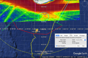
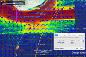
Posted on October 13th, 2018 No commentsRU29 is 125 nautical miles directly south of Galle, Sri Lanka. We objective is to continue moving Ru29 north towards Galle but to stay offshore of the 40 nautical mile wide (magenta line) shipping lanes. We have about 85 nautical miles (about 150 km) to go until we reach the southern side of the shipping lanes.
Ru29 has flown 50 km north in about 4 days. If we can keep up this speed, we can cover the next 150 km in 12 days, and be at the edge of the shipping lanes ready for pick up. So give us two weeks.
Today is Saturday, Oct 13. Two weeks from now is Saturday, Oct 27. So we would like to recover soon after Oct 27.
This plan depends on no major changes in the currents between our present location and our target location 150 km north. The last blog entry indicates that the models do not agree.
To determine which model is more likely to be correct, we did a test dive with the waypoint straight to the west. The compass heading rose shows the result. The red arrow shows the commanded heading. The light blue bars is a histogram in 30 degree increments of the direction RU29 actually flew. The dark blue arrow is the average heading, indicating we flew 120 degrees to the right of the waypoint, or towards 30 degrees east of north.
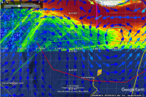
Here we zoom in to the location of RU29 and overlay the Copernicus currents. The glider moved to the northeast, and Copernicus says the currents by the glider are very low.
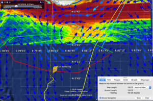
Now we remove the Copernicus currents and overlay the Hycom currents. HYCOM says the currents are strong and to the west. But the glider flew northeast.
Looks like the Copernicus model is giving us a better result more consistent with the observed glider behavior. Zooming even closer in on copernicus, there is an eddy just to the south of the shipping lanes. The distance from RU29 to the center of the eddy is about 140 km, so again, less than 2 weeks away. If we park there, the distance from Galle to Ru29 will be 66 nautical miles.
Hope is to bring RU29 a bit farther north than that, and sit at the outer edge of the shipping lanes, only 40 nautical miles from Galle.
