-
Sally tracks northwest, SG601 flies south
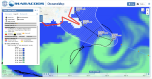
Posted on September 14th, 2020 No commentsThe image below is of the Navy GOFS sea surface salinity field. Enhancing this to focus the color bar on the salinities between 35 & 36 clearly shows the clockwise circulation of the warm eddy just southeast of the Mississippi delta. Sally is right over this warm eddy now, still as a tropical storm in this image. NHC forecast says it moving slowly and they say that it still has time to intensify. Glider SG601 is on the northern side of this ahead, just ahead of Sally. Kevin at USM is piloting it to the south to get into the eddy and even closer to the forecast track of Sally.

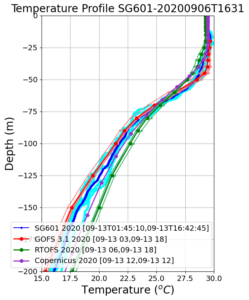
Lets take a look at the temperature profiles from SG601 and compare to the models moves more into the eddy and continues to experience the winds from Sally. Below the temperature profile is zoomed into the upper 200 m to get a look at the surface mixed layer in the upper 50 m where temperatures are in the 29C range. Below 50 m, we move into the thermocline, cross the 26C isotherm about 65 m depth. All models and data in good agreement down to about 75 m, then they diverge. GOFS (red) tends to stick with the Glider data (blue), while RTOFS (green) tends to be about 2C warmer between depths of 150 m to 200 m.

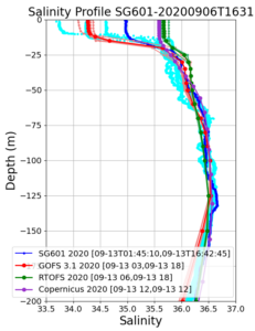
Salinity behavior is the opposite. Data and model are all in pretty good agreement below the mixed layer, but the salinity of the barrier layer varies widely. Note that the temperature mixed layer is 50 m deep, but the low salinity barrier layer is only 15 m deep. The salinity of the barrier layer is uncorrelated with temperature, so T-S relations don’t work, and you need to go out and measure the salinity. Light blue shows the spread in the salinity data from individual profiles. GOFS in red looks to be in with the mix of salinity profiles, which is expected, since only 1 salinity profile is chosen for assimilation each day. RTOFS has much less of a low salinity barrier layer.


