


-
OceansMap view of Cristobal
Posted on June 6th, 2020 No commentsHere are two quick views of Cristobal from OceansMap.
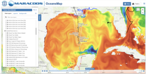
First we look at the current position and track of Cristobal over the Navy GOFS 3.1 model forecast for today’s Sea Surface Temperature. Cristobal is currently on the southern side of the Anticyclonic warm Loop Current Eddy. It will take most of today (Saturday) to cross over the eddy. Official NHC forecast has the intensity at 40 knots. The forecast is for a slight increase in intensity by about 11 mph as it crosses the Gulf with landfall Sunday.
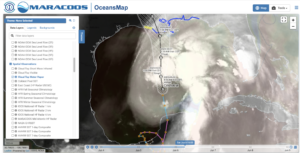
But Cristobal is a very broad storm as seen in the satellite cloud top water vapor product below, with the strongest convection to the north and east. The official NHC warnings extend well to the east of the expected landfall region.
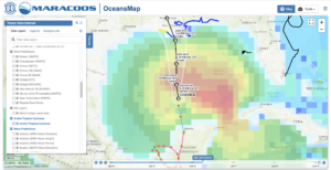
To get an idea of the scale of the impacts of this broad storm, we can check the global NOAA Wavewatch III model. The modeled waves indicate that this is a full-Gulf event.
Last 5 posts by Scott Glenn
- Early Season in the Mid Atlantic - June 17th, 2021
- Disturbance in the Gulf - June 16th, 2021
- Hurricane Gliders 2021 - May 3rd, 2021
- Hurricane Iota - November 16th, 2020
- Hurricane Eta - Low Wind Shear, High SST - November 2nd, 2020
