


-
HWRF-POM initialized with climatology and feature models
Posted on June 5th, 2020 No commentsThe last few blogs talked about what we see in the Navy GOFS 3.1, the data assimilative step on the ocean side of the coupled atmosphere-ocean hurricane models. My blog post from May 15, 2020 describes the multi-step process that gets us to the operational models. GOFS3.1 is the data assimilation step. This information flows into Global RTOFS to layer on the NOAA global windfields. But remember, these both are global models, their job is through data assimilation and the good windfields to get the Essential Ocean Features in the right locations. We then initialize a high resolution regional ocean model capable of resolving the Essential Ocean Processes that impact hurricane intensity during the rapid co-evolution phase of the atmosphere and ocean subject to intense hurricane forcing.
Another path to the regional scale ocean model underneath the hurricane is the feature model initialization process. Here climatology is modified by typical structural models for key Essential Ocean Features. In the Gulf of Mexico, a forecaster provides 3 points to describe the location of the Loop Current, and the a model for a typical Loop Current is inserted. For the warm eddies, climatology is modified by inserting bowl shaped structures to represent the warm core.
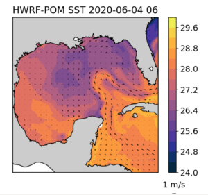
Here we investigate the results of that feature model initialization procedure used in the most recent HWRF-POM coupled forecast for Cristobal. The first image below is the Sea Surface temperature for the POM ocean model coupled to the HWRF atmospheric model. We see the Loop Current is present, but it looks to be shifted west of the Loop Current seen in the data assimilative GOFS or in the CoastWatch altimetry product. It definitely is not up against the West Florida Shelf as it exits the Gulf. Along the 90W line we have been talking about, the water is relatively warm on much of the Yucatan Shelf, with some upwelling occurring on the shelf. But as you head north along 90W and leave the Yucatan Shelf, you encounter some of the coldest water in the Gulf. The large warm eddy observed in GOFS and the CoastWatch altimetric product centered near 25N, 90W is absent from POM.

So lets layer on the surface currents to search for the structures in the current field. The GOFS experience taught us that the SST may be confusing due to surface processes, and that the sea surface height and the surface currents are better for identifying the eddies. Below is a plot of the POM ocean model SST and Surface currents. The Loop Current is certainly present, but the anticyclonic circulation we have been talking about since last night is absent.
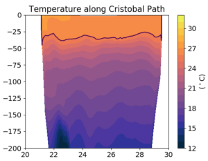
Ok, so lets just move straight to the subsurface section running from south to north along 90W. There is no bowl shaped warm core ring in the temperature section running from the Yucatan Shelf to the Louisiana Shelf. The 26C isotherm is pretty shallow, hovering around 30 m deep. Also wondering where the continental shelves on the north and south are. Looks like more to investigate.
Last 5 posts by Scott Glenn
- Early Season in the Mid Atlantic - June 17th, 2021
- Disturbance in the Gulf - June 16th, 2021
- Hurricane Gliders 2021 - May 3rd, 2021
- Hurricane Iota - November 16th, 2020
- Hurricane Eta - Low Wind Shear, High SST - November 2nd, 2020
