


-
Low Surface Salinity During Tropical Storm Karen
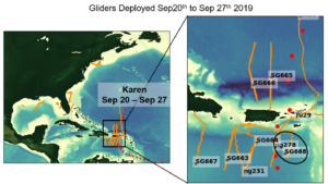
Posted on October 3rd, 2019 No commentsDuring Tropical Storm Karen, there were 10 gliders deployed in the Caribbean (below). On Sep 24, the eye Karen passed over Navy glider NG278, just south of St. Croix.
There is a good agreement in the vertical structure of temperature between GOFS 3.1 and the glider temperature (below).
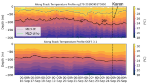
The GOFS 3.1 model, however, has a surface fresh layer (barrier layer) that is not as sharp as the observations show. This barrier layer gets even fresher and shallower during Karen (below). At the moment we are investigating if this freshening can be attributed to increased precipitation during the storm. If this is the case, this can be a mechanism that reinforces stratification during a storm and inhibits vertical mixing. We would like to investigate how important this possible mechanism is in controlling the storm intensity.
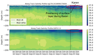
The freshening that happened during Karen (Sep 23 – Sep 24) is not initially captured by any of the models (below).
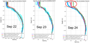
By Sep 26, the surface salinity in GOFS and Copernicus were much closer to the observations (both models assimilate data) but RTOFS still lags behind (below).

Images of these daily comparisons, since the inception of the 2019 hurricane season, are available here.
