


-
International Challenger RU29 Mission Update
Posted on September 12th, 2019 No commentsRU29 is tuning up to measure currents: RU29 spent the day profiling in about 1000 m depths off Virgin Gorda, with operators tweaking settings on the onboard Doppler current velocity profiler to optimize its ability to measure ocean currents. An important aspect of the mission will be measuring speed and direction of currents below the surface to determine the movement of the water masses distinguished by their temperature and salinity characteristics.
Currents in the region can be strong and have complex patterns. The figure below shows the modeled (US Navy AMSEAS model) currents in the region for 11 September, 2019. RU29 is in an area of northward surface currents greater than 1 knot. Ocean gliders themselves are only capable of forward speeds of around 0.5 knots, and only when they are ascending or descending. In order to make headway, they depend on spending most of their time well below the surface, where the currents are generally slower. If necessary, the glider does have a small electric motor and propeller which it can use, but at the cost of tapping into its limited battery reserves.
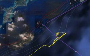
RU29 recent trackline and position on 11 September 2019. The glider should begin its trip across the Anegada Passage station line on 12 September.
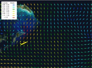
Modeled surface current vectors from the US Navy AMSEAS model from 2100 UTC, 11 September, 2019. From OCEANSMAP Caribbean.
To see all of the current reports, you can view them here: http://ocovi.azurewebsites.net/resource/Ru29
The International Challenger RU29 Mission is a collaboration among Rutgers University (New Brunswick, NJ) Center for Ocean Observing Leadership, Ocean and Coastal Observing – Virgin Islands (OCOVI, an affiliate of the US Integrated Ocean Observing System (IOOS) Caribbean Coastal and Ocean Observing System (CARICOOS)), and the University of the Virgin Islands. This mission will collect upper ocean data to improve hurricane forecasting models; study conditions in the Anegada Passage, an important region for NE Caribbean climate change; and build international cooperation for ocean observing and glider activities. The mission will work in the waters of the US Virgin Islands, British Virgin Islands, and Anguilla, under international Marine Science Research permit . Funding for the project comes from the U.S. National Oceanic and Atmosheric Adminstration through the IOOS, Rutgers University, and the G. Unger Vetlesen Foundation.
Last 5 posts by Mike Crowley
- RUCOOL Updates: January - April 2023 - May 5th, 2023
- RUCOOL Updates: October-December 2022 - February 1st, 2023
- RUCOOL Updates: July-September 2022 - November 17th, 2022
- RUCOOL Updates: April - June 2022 - July 19th, 2022
- RUCOOL Updates: February - March 2022 - April 26th, 2022
