


-
Test dive with waypoint straight west
Posted on October 13th, 2018 No commentsRU29 is 125 nautical miles directly south of Galle, Sri Lanka. We objective is to continue moving Ru29 north towards Galle but to stay offshore of the 40 nautical mile wide (magenta line) shipping lanes. We have about 85 nautical miles (about 150 km) to go until we reach the southern side of the shipping lanes.
Ru29 has flown 50 km north in about 4 days. If we can keep up this speed, we can cover the next 150 km in 12 days, and be at the edge of the shipping lanes ready for pick up. So give us two weeks.
Today is Saturday, Oct 13. Two weeks from now is Saturday, Oct 27. So we would like to recover soon after Oct 27.
This plan depends on no major changes in the currents between our present location and our target location 150 km north. The last blog entry indicates that the models do not agree.
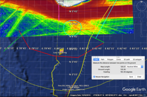
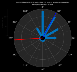
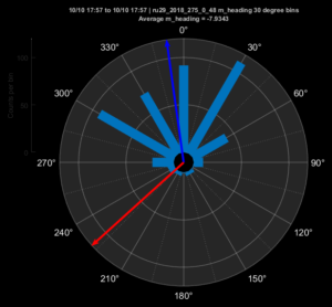
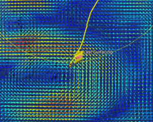
To determine which model is more likely to be correct, we did a test dive with the waypoint straight to the west. The compass heading rose shows the result. The red arrow shows the commanded heading. The light blue bars is a histogram in 30 degree increments of the direction RU29 actually flew. The dark blue arrow is the average heading, indicating we flew 120 degrees to the right of the waypoint, or towards 30 degrees east of north.
Here we zoom in to the location of RU29 and overlay the Copernicus currents. The glider moved to the northeast, and Copernicus says the currents by the glider are very low.
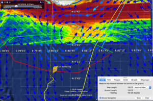
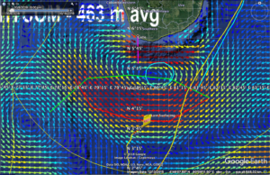
Now we remove the Copernicus currents and overlay the Hycom currents. HYCOM says the currents are strong and to the west. But the glider flew northeast.
Looks like the Copernicus model is giving us a better result more consistent with the observed glider behavior. Zooming even closer in on copernicus, there is an eddy just to the south of the shipping lanes. The distance from RU29 to the center of the eddy is about 140 km, so again, less than 2 weeks away. If we park there, the distance from Galle to Ru29 will be 66 nautical miles.
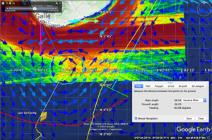
Hope is to bring RU29 a bit farther north than that, and sit at the outer edge of the shipping lanes, only 40 nautical miles from Galle.
-
Back to Sri Lanka
Posted on October 11th, 2018 No comments
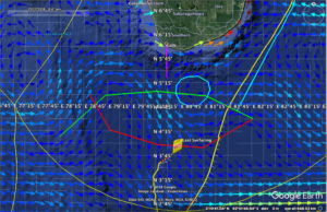
Waypoint is to the southwest, but RU29 is moving northeast, about 180 degrees from the waypoint. Ru29 is about 140 nautical miles south of Galle, the southern most port and the location of our recovery vessel. the red semi-circle is the 120 nautical mile circle from Galle. At 10 knots, this is a 12 hour boat ride from Galle.
Heading compass rose. Direction to waypoint is in red, to southwest. Histogram of observed heading in 30 degree increments in light blue. Average heading is dark blue arrow, which is almost directly north, or 135 degrees to the right of the commanded heading. But we are not heading north. We are heading northeast. There must be some eastward current.
Checking traffic, the busy shipping lane extends around the southern side of Sri Lanka a distance of 40 nautical miles offshore. We don’t want to come any closer than this.
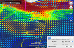
Now we zoom in and look at the currents. First Copernicus. Currents at the glider are to the southeast, so they have an eastward component. Between RU29 and Galle there is a wavy current that runs west to east. There is a low velocity region half way between Ru29 and Sri Lanka circled in cyan. The currents are counterclockwise around this low current region. So a counterclockwise eddy in Copernicus.
Hycom has an eddy in the exact same place as Copernicus, as seen by the cyan circle. But the circulation around the eddy in hycom is clockwise. The currents at the glider are strong and to the northwest. But the glider needs a current with an eastward component to produce the observed progress to northeast.
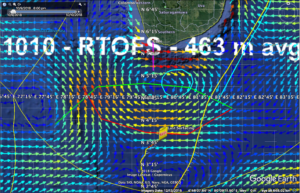
RTOFS has similar results to hycom, with a clockwise eddy between RU29 and Sri Lanka, and strong currents to northwest at the glider.
Looks like the Copernicus model wins today in this location. That means we should move the waypoint to direct our commanded heading to be more towards the south. A waypoint to the south would give us an actual glider flight direction 135 degrees to the right, or towards the northwest. Combine this with the eastward or southeastward currents, and we may get the east-west components to cancel each other, enabling us to make more progress directly to the north.
-
RU29 home-bound
Posted on September 23rd, 2018 No comments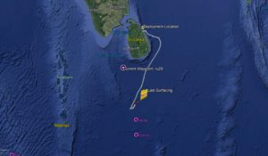
At roughly 120 km away from RAMA array 0N 80.5E RU29 turned back for Sri Lanka after the unfortunate loss of its rudder. With an 800 km journey ahead the glider can be estimate to be back on land in a month and a half if we travel at our safe speed of 20 km per day.
-
Missing Rudder Mystery
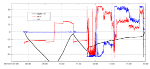
Posted on September 20th, 2018 No commentsRU29 ran into trouble today with the loss of his key piloting point. Initial contact increased glider’s buoyancy with a sharp upward pitch and an extreme port roll. Second contact changed glider’s roll to extreme starboard. Team speculates rudder was eventually lost at the end of second encounter at around 100 meters and surfaced with the help of pump and thruster. No large vessels were reported in area that could have interfered, however, fishing activity seems to be the likely culprit. Test dives followed at 10, 60, then 100 meters. Everything is working fine and roll is back to only a few degrees which means we did not lose glider wings.
-
RAMA Moorings
Posted on September 17th, 2018 No commentsHere is the dogleg track from Sri Lanka to Mauritius. The most northern RAMA mooring on the 81E line is a 4S. We would have to divert to a dues south path to get near it.
The most southern RAMA mooring on the 67E line is at 12 S, right along our intended path.
Looks like our fly-by of a RAMA mooring will wait for 12S, 67E.
-
One Salty Situation
Posted on September 17th, 2018 No comments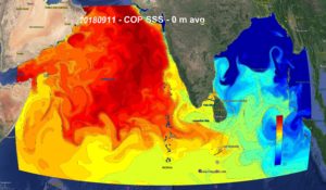
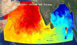
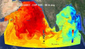
European model Copernicus and US Navy model HYCOM seems to show a high salinity tail coming out from Gulf of Oman/Arabian Sea and slowly drifting around Sri Lanka and into the Bay of Bengal. Salinity exceeds 36 psu and extends to 56m (according to Copernicus). This could cause trouble with glider flight patterns especially deep water profiling.
-
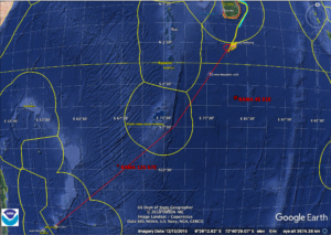
Out with the old in with the new
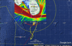
Posted on September 15th, 2018 No commentsToday RU 29 (finally) made it out of the Sri Lankan maritime border and is on its way to conquer a whirlwind of a situation. Naval ocean model HYCOM and NOAA ocean model RTOFS (depicted in Google Earth overlay figure below) picked up on an eddy spanning over 250 mi in width 400 mi in length that RU29 must cross in order to reach Mauritius off the coast of Africa. The glider may encounter surface velocities measuring from 0 to 0.3 m/s, with the highest velocities propelling the glider on its projected course.
-
Anchors aweigh!
Posted on September 13th, 2018 No comments
RU 29 has officially left Sri Lanka on August 12, 2018. Operating at a standard safe speed of 20 km per day RU 29 is scheduled to arrive at Mauritius, roughly 4,300 km away, in early March. The glider was granted scientific permission to enter British Indian Ocean Territory and anticipated to come within 50 miles off of the Diego Garcia Atoll. With this mission we will see exactly how well our global forecast models predict the variability in the Indian Ocean and what are the optimal paths for gliders to maximize their forecasting impact among other fascinating scientific discoveries that may occur throughout our journey. Stay tuned.
